Camping - GPS
 New
New
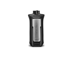
Garmin Alkaline Battery Pack Rino 750, 755t
Alkaline Battery Pack:
Replacement battery pack for Rino 700 series.
Uses 4 AA batteries, not included.
 New
New
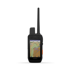
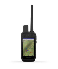
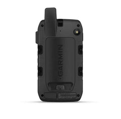
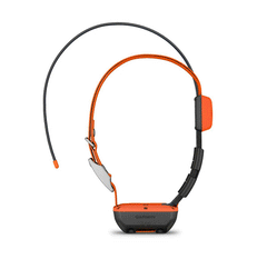
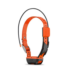
Garmin Alpha 200i Handheld
The Alpha 200i dog tracking and training system lets you monitor up to 20 dogs from up to 9 miles (depending on dog device) on a 3.5" display with a 2.5-second update rate. Easily control training functions by using the button-operated, dog-focused design.
You’ll also have access to premium Garmin navigation features, such as preloaded TopoActive maps, BirdsEye Satellite Imagery with direct-to-device downloads and built-in three-axis compass and barometric altimeter. Now, inReach® technology adds twoway messaging and interactive SOS alerts for peace of mind while you’re in the field.
LARGE 3.5"DISPLAY WITH SIX-BUTTON DESIGN
Features sunlight-readable 3.5" capacitive touchscreen display and a button-operated, dog-focused design for
quick, minor adjustments
TRACK YOUR PACK Monitor up to 20 dogs from up to 9 miles (depending on dog device) with a 2.5-second updaterate
DOG LIST AND GROUP MANAGEMENT Dog list and group management lets you keep inactive dogs in the system for easier setup
INREACH® TECHNOLOGY Interactive SOS alerts and two-way messaging via the 100% global Iridium® satellite network (satellite subscription
required)
MULTI-GNSS SUPPORT Access multiple global navigation satellite systems (GPS and Galileo) to track your pack with greater accuracy than GPS alone
TOPOACTIVE MAPS Our preloaded TopoActive mapping provides detailed views of terrain contours, topographic elevations, summits,
parks, coastlines, rivers, lakes and geographical points
BIRDSEYE SATELLITE IMAGERY Download BirdsEye Satellite Imagery directly to the handheld for better-than-real-life views of your route, trailheads,
clearings and more
NAVIGATION SENSORS A barometric altimeter helps you accurately monitor ascent and descent and see short-term trends in air pressure,
and the built-in tilt-compensated three-axis electronic compass keeps your bearing — whether you’re moving or not
TRAINING OPTIONS (TT™ 15/ TT 15 MINIONLY) When paired with TT™ 15 tracking and training collars, you will have access to 18 levels of continuous and
momentary stimulation, plus vibration and adjustable tones
FEDERAL PUBLIC LAND BOUNDARIES
Optional display of federal public land boundaries on topographical maps shows Bureau of Land Management,
National Parks and Wilderness so you know that you’re venturing where you’re supposed to be
HUNT TIMER FUNCTION Use the convenient timer mode during hunting competitions or field trials; get quick access to the timer with the new
user-configurable buttons
PRO VIEW COMPASS The pro view compass mode gives you simple, at-a-glance tracking that shows which direction and how far away
your dogs are, plus you will see when a dog is “Treed” or “On Point”
GARMIN EXPLORE™ Compatible with Garmin Explore website and app to help you manage tracks, routes and waypoints and review statistics from the field
ADDITIONAL MAPPING The microSD™ card slot allows you to load more mapping options, such as TOPO Australia and New Zealand. 24K
and Garmin HuntView™ Plus maps (sold separately)
GARMIN ECOSYSTEM Track your pack from the road, your wrist and other ways, thanks to wireless connectivity with compatible Garmin
devices, such as the Garmin DriveTrack™ 71 GPS navigator, fēnix® 6 GPS watches and more
BACKWARD COMPATIBLE Backward compatible so you can keep your existing collars and other Alpha compatible devices; transfer location
data between compatible Garmin devices
LONG-LASTING BATTERY Replaceable battery lasts up to 20 hours, or up to 15 hours with inReach technology enabled
 New
Sale
New
Sale
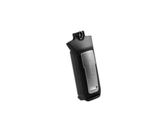
Garmin ACC Li-ION Battery Pack Rino7xx
For extended outings, bring an extra ithium-ion battery pack for your compatible Rino handheld.
Suitable for Garmin Rino 7XX
 New
Sale
New
Sale
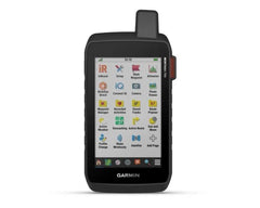
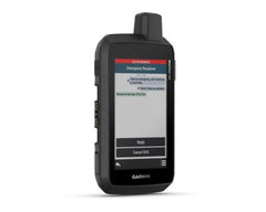
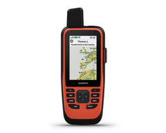
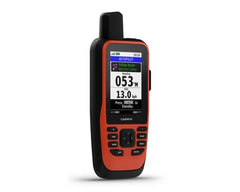
Garmin Montana 750i GPS AUS/NZ Topo
Montana® 750i
Rugged GPS Touchscreen Navigator with inReach® Technology and 8 Megapixel Camera
SEE THE WORLD. STAY IN TOUCH. BE THE PICTURE OF ADVENTURE.
The rugged Montana 750i handheld combines the flexibility of on- or off-road navigation with global messaging and interactive SOS via inReach satellite technology1 — plus a built-in 8-megapixel camera.
Big news. A full QWERTY keyboard lets you easily type messages.
Wander wider and still stay in touch — with inReach for messaging and 24/7 SOS.
Nav, meet cam. Put your trip pics on the map with geotags.
Routable TopoActive Australia and New Zealand maps. Now you’re free to take it off-road or on.
Meets MIL-STD 810 for thermal, shock, water and vibration.
Power your adventures with 18+ hours of lithium-ion battery life in GPS mode.
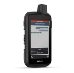
TWO-WAY MESSAGING
Exchange text messages with loved ones, post to social media, or communicate via inReach device to inReach device in the field (active satellite subscription required).
INTERACTIVE SOS
In case of emergency, trigger an interactive SOS message to GEOS, a professional 24/7 global monitoring and response center (active satellite subscription required).
GLOBAL CONNECTIVITY
Instead of relying on cellphone coverage, now your messages, SOS and tracking are transferred via the 100% global Iridium® satellite network (active satellite subscription required).
INREACH WEATHER
Available inReach weather forecast service provides detailed updates directly to your Montana handheld or paired devices, so you’ll know what to expect en route.
RUGGED BY DESIGN
This durable, water-resistant handheld is tested to U.S. military standards and features a glove-friendly 5” touchscreen that’s 50% larger than previous Montana models.
BUILT-IN CAMERA
Capture images of your exploits with Montana’s digital 8-megapixel camera. It geotags photos with coordinates, so you can navigate back to favourite sites in the future.
CITY NAVIGATOR MAPS
Seamlessly transition from trails to road navigation with preloaded City Navigator street mapping, which guides your drive with easy-to-follow turn-by-turn directions.
TOPOACTIVE AUSTRALIA AND NEW ZEALAND MAPS
To navigate your adventures, use preloaded TopoActive Australia and New Zealand maps. View elevations, coastlines, rivers, landmarks and more.
SATELLITE VIEWS
Use direct-to-device downloads of BirdsEye Satellite Imagery (no annual subscription required) to see photo-realistic views and create waypoints based on landmarks.
ABC SENSORS
Navigate your next trail with ABC sensors, including an altimeter for elevation data, barometer to monitor weather and 3-axis electronic compass.
ACTIVE WEATHER
Use cellular connectivity2 to access up-to-date Active Weather forecasts through the Garmin Connect™ app.
DOG TRACKING
For hunters and trainers, this Montana syncs with compatible Astro® or Alpha® series handhelds (sold separately) to help track sporting dogs in the field.
MULTI-GNSS SUPPORT
Access to GPS, GLONASS and GALILEO satellite networks enables Montana® 750i to track in more challenging environments than GPS alone.
TRACKING
Track your location, and share it with those at home or out in the field. They´ll be able to see your progress or ping your device for your GPS location and more via your web-based MapShare™ trip-sharing page. (Montana 700i, 750i only - satellite subscription required).
EXPEDITION MODE
Trek far and wide off-grid. Use Expedition mode, an ultralow-power GPS reference, to keep Montana tracking for a week or more between recharges.
EXTENDED BATTERY LIFE
An internal, rechargeable lithium-ion battery pack provides more than 18 hours of battery life in GPS mode.
VEHICLE MOUNTS
A variety of Montana handheld-compatible mounts (sold separately) lets you adapt your navigator for use on ATVs, boats, cars, motorcycles, RVs or other vehicles.
PHYSICAL DIMENSIONS 9.19 x 18.30 x 3.27 cm
TOUCHSCREEN
DISPLAY SIZE 6.48 x 10.80 cm; 5" diag (12.70 cm)
DISPLAY RESOLUTION 480 x 800 pixels
DISPLAY TYPE WVGA transflective, dual orientation
WEIGHT 410 g with included lithium-ion battery pack
BATTERY TYPE rechargeable lithium-ion (included)
BATTERY LIFE GPS Mode: up to 18 hours
Expedition Mode: up to 330 hours
GPS Mode, 10 min Tracking: up to 18 hours
Expedition Mode, 30 min Tracking: up to 300 hours
WATER RATING IPX7
MIL-STD-810 yes (thermal, shock, water, vibe)
HIGH-SENSITIVITY RECEIVER
INTERFACE High speed micro USB and NMEA 0183 compatible
MEMORY/HISTORY 16 GB (user space varies based on included mapping)
PRELOADED MAPS Yes (TopoActive Australia and New Zealand)
 New
Sale
New
Sale
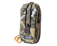
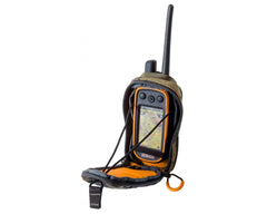
Hunters Element Latitude GPS Pouch
Take your technology hunting with the confidence of protection with easy access with the Hunters Element GPS Pouch!
Features:
• Attaches to multiple gear
• Quiet access
• Fits large range of radio, GPS, handsets and tracking devices
• Colour: Desolve veil camo
• Dimensions (H x W): 17cm x 8cm
 New
Sale
New
Sale
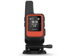
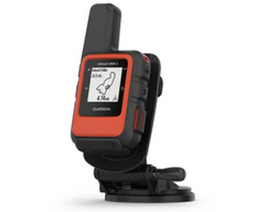
Garmin inReach Mini 2 Flame Red Marine Bundle
HOME IS CLOSER THAN YOU THINK.
This compact satellite communicator helps you keep home with you when you’re off the grid — adding peace of mind to every adventure, without adding weight to your pack.
MARINE BUNDLE
The bundle includes a screw down mount and power cable, so you can mount your inReach device at your helm for easy access in a moment’s notice.
Key Features:
• Global satellite coverage keeps you connected when cellphones can’t
• In an emergency, send an interactive SOS message to our coordination center
• You can still connect to the ones who matter, even without cellphone coverage
• With TracBack® routing, find your way back if you happen to get lost
• Expand the capabilities of your inReach device by using the Garmin Explore™ app
• Stay on adventures longer with up to 14 days of battery life in 10-minute tracking mode
Stay in touch using inReach technology.
• TWO-WAY MESSAGING.
• INTERACTIVE SOS ALERTS.
• LOCATION SHARING.
• GLOBAL SATELLITE NETWORK.
• FLEXIBLE SATELLITE AIRTIME PLANS.
• COMPACT, RUGGED DESIGN.
Your adventure-ready companion.
• TRACBACK ROUTING.
• DIGITAL COMPASS.
• BATTERY LIFE.
• INREACH WEATHER FORECAST SERVICE.
• UNLIMITED CLOUD STORAGE AND TRIP PLANNING.
Connect to more capabilities.
• GARMIN EXPLORE APP.
• OTHER GARMIN DEVICES
• GARMIN PILOT™ APP.
Specifications:
• DIMENSIONS: 2.04” x 3.90” x 1.03” (5.17 x 9.90 x 2.61 cm)
• DISPLAY SIZE: 0.9" x 0.9" (23 x 23 mm)
• DISPLAY RESOLUTION: 176 x 176 pixels
• DISPLAY TYPE: sunlight-readable, monochrome, transflective memory-in-pixel (MIP)
• WEIGHT: 3.5 oz (100.0 g)
• BATTERY TYPE: Rechargeable internal lithium-ion
BATTERY LIFE:
Up to 14 days at 10-minute tracking send interval with standard activity recording with full sky view
Up to 4 days with moderate tree cover (default)
Up to 5 days at 10-minute tracking send interval with high detail activity recording with full sky view
Up to 2 days with moderate tree cover
Up to 30 days at 30-minute tracking send interval with standard activity recording with full sky view
Up to 10 days with moderate tree cover
Up to 1 year when powered off
• WATERPROOF: IPX7
• INTERFACE: USB-C
Maps & Memory
• WAYPOINTS/FAVORITES/LOCATIONS: 1000
• COURSES: 100
• ACTIVITIES: 200
Sensors
• HIGH-SENSITIVITY RECEIVER: yes
• GPS: yes
• GALILEO: yes
• QZSS: yes
• COMPASS: yes
• GPS COMPASS (WHILE MOVING): yes
Daily Smart Features
• WEATHER: yes
• POINT-TO-POINT NAVIGATION: yes
inReach® Features
• INTERACTIVE SOS: yes
• SEND AND RECEIVE TEXT MESSAGES TO SMS AND EMAIL: yes
• SEND AND RECEIVE TEXT MESSAGES TO OTHER INREACH DEVICE: yes
• EXCHANGE LOCATIONS WITH OTHER INREACH DEVICE: yes
• MAPSHARE COMPATIBLE WITH TRACKING: yes
• VIRTUAL KEYBOARD FOR CUSTOM MESSAGING: yes
• INREACH REMOTE COMPATIBLE: yes
Outdoor Applications
• COMPATIBLE WITH GARMIN EXPLORE™ APP: yes
• GARMIN EXPLORE WEBSITE COMPATIBLE: yes
• GARMIN PILOT™ APP COMPATIBLE: yes
Connections
• CONNECTIONS WIRELESS CONNECTIVITY: yes (BLUETOOTH®, ANT+®)
 New
New
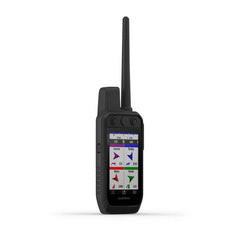
Garmin Alpha 200 GPS Handheld Multi-Dog Tracking Device
STRONG CONNECTION. STRONG BOND. Track and train your dogs with the Alpha 200, Handheld Only system, a sunlight-readable 3.50″ capacitive touchscreen and user-friendly, six-button design.
Key Features:
• This handheld is designed to help make tracking and training simple, accessible and fast.
• Track and train your pack while they’re out in the field.
• Keep inactive dogs in the system for easier setup and management.
• Navigate every hunt with the best in Garmin mapping and sensors.
• User-replaceable battery lasts up to 20 hours.
TRACK YOUR PACK. Monitor up to 20 dogs from up to 14.50 kilometres (depending on dog device) with a 2.50-second update rate.
DOG LIST/GROUP MANAGEMENT. Keep inactive dogs in your dog list, and manage active groups so you don’t have to add and remove dogs for every hunt.
PUBLIC LAND BOUNDARIES. Optional display of public land boundaries on topographical maps helps you know that you’re venturing where you’re supposed to be.
HUNT METRICS. See each dog’s daily hunting patterns, distance and speed so you can monitor performance and help prevent overheating. Pair with TT™ 15 tracking and training collars.
SIX-BUTTON DESIGN. Use dedicated buttons for fast training cues and minor adjustments in the field.
18 LEVELS OF STIMULATION. Momentary and continuous stimulation options let you customise training for each dog.
TONE/VIBRATION. Issue different levels of audible tone or vibration commands for quick adjustments to individual dogs.
GARMIN EXPLORE™ APP. Pair with the Garmin Explore app on your compatible smartphone to see real-time dog tracking information, save collections of dog tracks and replay tracks to see exactly what happened during your hunt.
PRO VIEW COMPASS. The pro view compass mode gives you simple, at-a-glance tracking that shows which direction and how far away your dogs are, plus you will see when a dog is “Treed” or “OnPoint.”
MULTI-GNSS SUPPORT. Access multiple global navigation satellite systems (GPS and Galileo) to track your pack with greater accuracy than GPS alone.
TOPOACTIVE MAPS. Our preloaded TopoActive mapping provides detailed views of terrain contours, topographic elevations, summits, parks, coastlines, rivers, lakes and geographical points.
BIRDSEYE DIRECT. Download BirdsEye Satellite Imagery directly to the handheld for better-than-real-life views of your route, trailheads, clearings and more.
NAVIGATION SENSORS. A barometric altimeter helps you accurately monitor ascent and descent and see short-term trends in air pressure, and the built-in tilt-compensated 3-axis electronic compass keeps your bearing - whether you’re moving or not.
SEE IT ALL. The sunlight-readable 3.50″ capacitive touchscreen display makes it easy to see and interact with your maps, dog data and more — even while wearing gloves.
STAY ON THE MOVE. Replaceable battery lasts up to 20 hours, giving you plenty of hunt time with your dogs in the field.
ADDITIONAL MAPPING. The microSD™ card slot allows you to load more mapping options, such as TOPO Australia and New Zealand Light and HuntView maps (each sold separately).
Specifications:
General
• PHYSICAL DIMENSIONS: 7.70 x 6.40 x 1.30″ (6.80 x 16.20 x 3.40 cm) *dimensions do not include antenna
• TOUCHSCREEN: Yes
• DISPLAY SIZE: 1.80″ W x 3.0″ H (4.70 x 7.70 cm); 3.50″ diag (88.90 mm)
• DISPLAY RESOLUTION: 282 x 470 pixels
• DISPLAY TYPE: Transflective, colour TFT touchscreen
• WEIGHT: 9.90 oz (280 g) with standard antenna and battery
• BATTERY TYPE: Rechargeable lithium-ion (included)
• BATTERY LIFE: Up to 20 hours
• WATER RATING: IPX7
• HIGH-SENSITIVITY RECEIVER: Yes
• INTERFACE: High-speed USB
• MEMORY/HISTORY: 16 GB
• PRODUCT NUMBER: 010-02616-53
Maps & Memory
• PRELOADED MAPS: Yes (TopoActive)
• ABILITY TO ADD MAPS: Yes
• BASEMAP: Yes
• AUTOMATIC ROUTING (TURN BY TURN ROUTING ON ROADS) FOR OUTDOOR ACTIVITIES: Yes (with optional mapping for detailed roads)
• BIRDSEYE: Yes, direct to device (no annual subscription required)
• EXTERNAL MEMORY STORAGE: microSD™ card (not included)
• WAYPOINTS/FAVORITES/LOCATIONS: 10,000
• TRACKS: Up to 20 dogs (TT 15/TT 15 mini and T5/T5 mini) and buddies (Alpha 100 and Alpha 200) simultaneously
• TRACK LOG: 20,000 points, 200 saved gpx tracks, 300 saved fit activities
• ROUTES: 250
• STORED CONTACTS: 250 dogs
• GROUP MANAGEMENT: Yes
Sensors
• BAROMETRIC ALTIMETER: Yes
• COMPASS: Yes (tilt-compensated 3-axis)
Outdoor Recreation
• SUN AND MOON INFORMATION: Yes
• CUSTOM MAPS COMPATIBLE: Yes
Two-way Radio Features
• FREQUENCY BAND: MURS
• RANGE: TT 15/T5, 14.50 kilometres; TT 15 mini/T mini, 14.50 kilometres
Outdoor Applications
• COMPATIBLE WITH GARMIN EXPLORE™ APP: Yes
• GARMIN EXPLORE WEBSITE COMPATIBLE: Yes
Connections
• WIRELESS CONNECTIVITY: Yes (Wi-Fi®, Bluetooth® and ANT+®)
 New
Sale
New
Sale
Garmin Montana 700i GPS AUS/NZ Maps
Keep adventurers in touch and on track, the Montana 700i handheld combines the flexibility of on- or off-road navigation with global messaging and interactive SOS via inReach satellite technology1.
Big news. A full QWERTY keyboard lets you easily type messages. Wander wider and still stay in touch — with inReach for messaging and 24/7 SOS. Routable TopoActive Australia and New Zealand maps. Now you’re free to take it off-road or on. Meets MIL-STD 810 for thermal, shock, water and vibration. Get the clear perspective of BirdsEye Satellite Imagery right to your device. Power your adventures with 18+ hours of lithium-ion battery life in GPS mode. Exchange text messages with loved ones, post to social media, or communicate via inReach device to inReach device in the field (active satellite subscription required).
Features:
• INTERACTIVE SOS
• GLOBAL CONNECTIVITY
• INREACH WEATHER
• RUGGED BY DESIGN
• CITY NAVIGATOR MAPS
• TOPOACTIVE AUS & NZ MAPS
• SATELLITE VIEWS
• ABC SENSORS
• ACTIVE WEATHER
• DOG TRACKING
• TRACKING
• EXPEDITION MODE
• EXTENDED BATTERY LIFE
• VEHICLE MOUNTS
PHYSICAL DIMENSIONS 9.19 x 18.30 x 3.27 cm
TOUCHSCREEN
DISPLAY SIZE 6.48 x 10.80 cm; 5" diag (12.70 cm)
DISPLAY RESOLUTION 480 x 800 pixels
DISPLAY TYPE WVGA transflective, dual orientation
WEIGHT 410 g with included lithium-ion battery pack
BATTERY TYPE rechargeable lithium-ion (included)
BATTERY LIFE GPS Mode: up to 18 hours
Expedition Mode: up to 330 hours
GPS Mode, 10 min Tracking: up to 18 hours
Expedition Mode, 30 min Tracking: up to 300 hours
WATER RATING IPX7
MIL-STD-810 yes (thermal, shock, water, vibe)
HIGH-SENSITIVITY RECEIVER
INTERFACE High speed micro USB and NMEA 0183 compatible
MEMORY 16 GB (user space varies based on included mapping)
 New
Sale
New
Sale
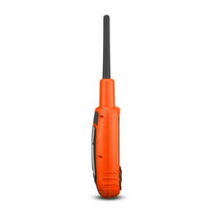
Garmin Alpha T 20 GPS Dog Tracking Collar
TRACK YOUR PACK.
No matter what kind of dogs you run or how you hunt, Garmin Alpha® T 20 is the slim, rugged and universally sized collar designed to help you build a better dog — no matter the breed.
Key Features:
- Track your dog up to 14.5 kilometers when used with a compatible handheld (sold separately)
- Optimise your battery life with dynamic tracking
- Collar is universally sized to fit large and small breeds
- Easily change the user-replaceable flex band
- Uses multicolour location beacon for low-light conditions
- Get automatic software updates when charging and connected to your network with Wi-Fi® technology
TRACKING
The top-mounted, high-sensitivity GPS and Galileo receiver keeps track of your dog’s location, and the Alpha® T 20 collar transmits that location via VHF up to 14.5 kilometers away with updates as frequent as every 2.5 seconds when used with a compatible handheld (sold separately).
UNIVERSAL SIZING
A rugged yet slim design is universally sized to fit large and small breeds.
DYNAMIC TRACKING
Get extended battery life with dynamic tracking based on your dog’s movement.
RUGGED DESIGN
The collar features a user-replaceable flex band that can withstand the toughest outdoor environments.
LED BEACON LIGHTS
This collar features bright, multicolour LED beacon lights to help you identify and track your dog in low-light conditions. They can be remotely activated and changed from a compatible handheld (sold separately).
REPLACEABLE BATTERY PACKS
When using dynamic tracking, get up to 68 hours with the standard battery pack and up to 136 with the extended battery pack (sold separately).
AUTOMATIC UPDATES
Receive automatic software updates when Alpha® T 20 is charging and connected to your network with Wi-Fi technology.
PAIR WITH HANDHELDS
The Alpha® T 20 GPS dog collar easily pairs with Garmin dog tracking handhelds, such as the Alpha® series (sold separately).
Specifications:
- Unit dimensions (WxHxD): 8.1 x 4.5 x 3.5 cm (3.2″ x 1.8″ x 1.4″)
- Weight: 168.5 g (5.9 oz) for transmitter and antenna (without collar), 239.5 g (8.4 oz) total weight (with collar)
- Battery type: Rechargeable lithium-ion pack; user-replaceable
- Battery life: Standard battery pack (included) - up to 68 hours using dynamic tracking (default), up to 25 hours with location updates every 2.5 seconds, up to 84 hours with location updates every 2 minutes, Extended battery pack (sold separately), up to 136 hours using dynamic tracking (default), up to 50 hours with location updates every 2.5 seconds, up to 168 hours with location updates every 2 minutes
- Range: 14.5
- Interface: USB-C
- Water rating: 1 ATM (10 metres)
- Neck size: With standard 1″ collar strap: minimum of 9.5″ (24 cm) in circumference, With flipped 1″ collar strap: minimum of 6.5″ (16.5 cm) in circumference
- High-sensitivity GPS/Galileo receiver: Yes
- GPS antenna: Top-mounted, orange
- Vibration/Tone: Not available in the U.S.; may be available in other regions
- LED beacon lights: Yes (multiple colour options)
- Flex band: User-replaceable
- Sleep mode: Yes (Alpha® Series only)
- Rescue mode: Yes
- Frequency mode: VHF
- Replaceable collar straps: Yes
- Collar compatibility: Up to 1″ (2.54 cm)
- Automatic software updates: Wi-Fi® technology (when charging and connected to a network)
- Manufacturer code: 010-02447-03
 New
New
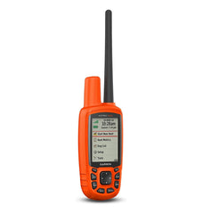
Garmin Astro 430 GPS Dog Tracker Handheld
Handheld Tracking System for Sporting Dogs
With faster 2.5-second location updates and the capacity to follow up to 20 dogs¹, Astro 430 is a handheld powerhouse of dog-tracking performance. Intuitive and easy to use, the Astro 430 handheld features a vibrant 2.6-inch color display, preloaded TOPO Lite AU/NZ mapping, an optional in-unit rechargeable battery and Hunt Metrics data to help analyse your dogs’ tracking habits in the field, so you can know how to train more effectively.
Key Features:
- Track up to 20 dogs at a time, with ranges up to 9 miles using a Garmin T 5 collar device
- 2.5-second update rate provides faster location tracking when dogs are on the run
- GPS/GLONASS reception enables better satellite tracking in challenging environments than GPS alone
- Comes with preloaded TOPO Lite AU/NZ mapping; compatible with Garmin HuntView cards
- Hunt Metrics data helps analyse your dogs’ hunting patterns and behaviors; view distance traveled, time afield and more
Follow Your Dog's Every Move
Using the Garmin T 5 collar devices² (sold separately) to transmit each dog’s location as often as every 2.5 seconds, Astro 430 is quick to pinpoint the track they’re following — even when they’re on the run. On the Astro’s bright, crisp display, you can see your dog’s current location and a trail of where he’s been. You also can switch over to the Dog Track page to view a compass pointing to your dog’s location. For help in keeping the big picture in sight when tracking multiple dogs, it’s easy to auto zoom the map page, so all dogs can be seen on the display at any time. Dogs that are too far away to fit on the map’s current zoom scale can be notated on the display’s margin in the direction of the dog’s location. To reduce visual clutter on the map, you can toggle between “show all,” “show some” and “show none” — selecting the duration that each dog’s track is viewable on the display. You can also share a dog’s track code so another person can view your dog’s location on their unit’s map, along with the dog tracking compass. Further, by sharing a dog’s control code, you can allow another person to configure and control your dog’s on-collar device.
See More Detail with Additional Mapping
Astro 430 features a microSD™ card slot that allows you to load even more mapping options, such as TOPO Lite AU/NZ and HuntView maps (sold separately). You also can opt for City Navigator AU/NZ map data that gives you turn-by-turn driving directions on roads.
Astro 430 is also compatible with Garmin Custom Maps, free software that transforms paper and electronic maps into downloadable maps for your device.
Track with Hunt Metrics Data
Sophisticated Hunt Metrics help monitor your dog’s hunting patterns and behaviors to optimize your training opportunities. You can see your dog's times, distances traveled and overall scores. Plus, the Astro 430 will also capture the number of times during the hunt when an “on point” or “treed” event was indicated.
Count Your Coveys
After you’ve tracked down your quarry, mark the exact spot with Astro’s Covey Counter™, a special waypoint that shows the exact location, time of day and elevation where you found your prey as well as the number of birds you flushed and took from that location. Astro lets you save other special waypoints, such as “Truck” and “Lodge,” so you can easily find your way back to these locations at the end of the hunt. Astro also offers special waypoint icons to represent food plots, tree stands and other hunting-related points.
Share Wirelessly
With an expanded ecosystem of wireless connectivity options, Astro 430 can support unit-to-unit data transfer with a variety of compatible Garmin devices. For example, the outdoor Garmin DriveTrack™ 70 GPS navigator can receive and display dog positions on its moving map — with TOPO or satellite image views — showing navigation cues to your dog’s current location. Likewise, fēnix® 3 GPS watches can receive dog status updates and alerts for viewing at a glance on your wrist. Also, while you’re in the field, Astro 430 lets you link and share wirelessly with your buddies’ compatible devices, such as the Oregon® handheld, Montana® handheld, GPSMAP® 64 chartplotter or other ANT+® enabled devices, to help coordinate hunt logistics on the go.
Turn Your Computer Into a BaseStation for Tracking Dogs
Load your laptop with BaseStation software to turn it into a field control center for tracking multiple dogs (equipped with T 5 dog devices²). View real-time GPS information on the larger display of your computer, making it ideal for canine search and rescue teams. And because it’s GPS/GLONASS capable, you'll get tracking, even where Internet and cell phone service isn’t available.
Tough, Water-resistant, Long-lasting
Like all Garmin outdoor products, Astro 430 is designed to be effective, easy to use, reliable and rugged enough to withstand all the blows, bumps and sloppy conditions of training and hunting. The handheld unit is water-resistant to IPX7, and it can be powered with standard AA batteries — or it’s optionally available with a long-lasting NiMH battery pack that’s rechargeable in the unit. What’s more, if you ever drop or misplace your Astro 430 in the field, the high-visibility orange case makes it easy to track down.
Specifications:
General
- DIMENSION: 2.4" x 6.3" x 1.4" (6.1 x 16.0 x 3.6 cm)
- DISPLAY SIZE: 1.43" x 2.15" (3.6 x 5.5 cm); 2.6" diag (6.6 cm)
- DISPLAY RESOLUTION: 160 x 240 pixels
- DISPLAY TYPE: transflective, 65-K color TFT
- WEIGHT: 9.2 oz (260.1 g) with batteries
- WATERPROOF: IPX7
- BATTERY TYPE: Optional NiMH pack or 2 standard AA (not included)
- BATTERY LIFE: up to 20 hours (Astro 430)
- MEMORY/HISTORY: 4 GB
Maps & Memory
- PRELOADED MAPS: yes (TOPO)
- ABILITY TO ADD MAPS: yes
- BASEMAP: yes
- AUTOMATIC ROUTING (TURN BY TURN ROUTING ON ROADS) FOR OUTDOOR ACTIVITIES: Yes (with optional mapping for detailed roads)
- EXTERNAL MEMORY STORAGE: microSD™ card (not included)
- WAYPOINTS/FAVORITES/LOCATIONS: 2000
- NAVIGATION TRACK LOG: 10,000 points, 200 saved tracks
- NAVIGATION ROUTES: 200
Sensors
- HIGH-SENSITIVITY RECEIVER: Yes
- BAROMETRIC ALTIMETER: Yes
- COMPASS: Yes (tilt-compensated 3-axis)
Outdoor Recreation
- AREA CALCULATION: Yes
- HUNT/FISH CALENDAR: Yes
- SUN AND MOON INFORMATION: Yes
- GEOCACHING-FRIENDLY: Yes (Paperless)
- CUSTOM MAPS COMPATIBLE: Yes
Additional
- Range (line of sight): T Series: 9 miles; T mini Series: 4 miles
- Frequency band: The T Series and the TT Series dog collars cannot be tracked simultaneously by both the Astro 320 and Astro 430.
- Handhelds vibration mode: yes
- Tracks up to 20 dogs simultaneously
Manufacturer code: 010-01635-53
Included:
- Astro 430 handheld
- 5" standard and 13" extended range antennas
- Belt clip
- USB cable
- Documentation
 New
Sale
New
Sale
Garmin 86i GPS Map
CAST OFF CONFIDENTLY WITH A PREMIUM MARINE HANDHELD GPS
Stay on course with the GPSMAP 86i handheld. It provides all the outdoor functions and global communications of the GPSMAP® 66 series and adds on-the-water features — including wireless connectivity to your onboard marine system.
Features:
- It’s water resistant, and it floats, so it’s as at home on the water as you.
- See all your marine system info at a glance with boat data streaming.
- Cruise with peace of mind. inReach interactive SOS is there if you need it2.
- Send and receive text messages from anywhere2.
- Put convenient control of your autopilot and Fusion® systems at your fingertips.
- Stay out longer with up to 35 hours of battery life in 10-minute tracking mode.
BOAT DATA
Sync with compatible Garmin chartplotters and instruments to see real-time boat data displayed right on your handheld.
FUSION-LINK AUDIO
Get convenient remote operation of select onboard Fusion marine products.
ACCURATE TRACKING
When you’re underway, an adjustable GPS filter smooths speed and heading indications as you pass over swells for more accurate tracking.
WORLDWIDE BASEMAP
See worldwide shaded relief coverage, including oceans, seas, major lakes and rivers. And see international and state political boundaries and time zone information.
BLUECHART COVERAGE
Add optional BlueChart g3 coastal charts give you leading-edge coverage, clarity and detail with integrated Garmin and Navionics data.
AUTOPILOT REMOTE
Even when you’re not at the helm, you can control your boat. Access the autopilot app to change heading, engage pattern steering and follow a GPS route.
BACKUP NAVIGATION
Whether you’re out for a day of fishing, sailing or cruising, gain peace of mind that comes from having a backup navigator.
ABC SENSORS
Navigate anywhere with ABC sensors, including an altimeter for elevation data, barometer to monitor weather and 3-axis electronic compass.
TWO-WAY MESSAGING
The Iridium® satellite network1 lets you send and receive custom and preset text messages or emails with a delivery confirmation2.
TRIP TRACKING
Share your adventures with your web-based MapShare™ trip-sharing page so loved ones can see your progress or ping your device to see your GPS location2.
INTERACTIVE SOS
In case of emergency, trigger an interactive SOS message to the Garmin IERCC, a 24/7 staffed professional emergency response coordination centre via the 100% global Iridium satellite network.
MARINE WEATHER
Receive weather forecasts directly on your device, so you can make educated decisions based on local conditions or the destination ahead2.
Stay connected.
SMART NOTIFICATIONS
Get smart notifications right on your GPSMAP 86i handheld when you pair it with your compatible smartphone.
GARMIN EXPLORE™ APP
Sync GPSMAP 86i with Garmin Explore for cloud management of your favourite waypoints, tracks and routes.
WIRELESS CONNECTIONS
GPSMAP 86i offers Wi-Fi® connectivity, ANT+® technology and Bluetooth® wireless technology for easy wireless updates and connections.
LED FLASHLIGHT
The GPSMAP 86i helps you keep gear to a minimum with a built-in LED flashlight that can be used as a beacon to signal for help.
BATTERY LIFE
The internal, rechargeable lithium battery provides up to 35 hours of battery life in 10-minute tracking mode and up to 200 hours in expedition mode3.
In the Box:
- GPSMAP 86i handheld with worldwide basemap
- Powered mount
- Lanyard
- USB to Micro USB cable
- USB to 2 pin cable
- Mounting hardware
- Documentation
Specifications:
- DIMENSION: 2.65" x 7" x 1.7" (6.75w x 17.8h x 4.4d cm)
- DISPLAY SIZE: 1.5"W x 2.5"H (3.8 x 6.3 cm); 3" diag (7.6 cm)
- DISPLAY RESOLUTION: 240 x 400 pixels
- DISPLAY TYPE: transflective, 65K color TFT
- WEIGHT: 9.59 oz (272 g)
- WATERPROOF: IPX7
- BATTERY TYPE: rechargeable, internal lithium-ion
- BATTERY LIFE: up to 35 hours at 10-minute tracking; up to 200 hours at 30-minute tracking (power save mode)
- MIL-STD-810 yes (thermal, shock, water)
- INTERFACE high speed microUSB and NMEA 0183 compatible
- MEMORY/HISTORY 16 GB (user space varies based on included mapping)
- ABILITY TO ADD MAPS: Yes
- BASEMAP: Yes
- MAP SEGMENTS: 15000
- SATELLITE IMAGERY: yes (direct to device)
- INCLUDES SEARCHABLE POINTS OF INTERESTS (PARKS, CAMPGROUNDS, SCENIC LOOKOUTS AND PICNIC SITES): Yes (downloadable from Garmin Express™)
- DISPLAYS NATIONAL, STATE AND LOCAL PARKS, FORESTS, AND WILDERNESS AREAS: Yes (downloadable from Garmin Express™)
- EXTERNAL MEMORY STORAGE: yes (32 GB max microSD™ card, not included)
- WAYPOINTS/FAVORITES/LOCATIONS: 10000
- TRACKS: 250
- NAVIGATION TRACK LOG: 20,000 points, 250 saved gpx tracks, 300 saved fit activities
- NAVIGATION ROUTES: 250, 250 points per route; 50 points auto routing
- RINEX LOGGING: Yes
- HIGH-SENSITIVITY RECEIVER: Yes
- GPS: Yes
- GALILEO: Yes
- BAROMETRIC ALTIMETER: Yes
- COMPASS: Yes (tilt-compensated 3-axis)
- GPS COMPASS (WHILE MOVING): Yes
- CONNECT IQ™ (DOWNLOADABLE WATCH FACES, DATA FIELDS, WIDGETS AND APPS): Yes
- SMART NOTIFICATIONS ON HANDHELD: Yes
- VIRB® REMOTE: Yes
- PAIRS WITH GARMIN CONNECT™ MOBILE: Yes
- ACTIVE WEATHER: Yes
- LIVETRACK: Yes
- POINT-TO-POINT NAVIGATION: Yes
- AREA CALCULATION: Yes
- HUNT/FISH CALENDAR: Yes
- SUN AND MOON INFORMATION: Yes
- XERO™ LOCATIONS: Yes
- GEOCACHING-FRIENDLY: yes (Geocache Live)
- CUSTOM MAPS COMPATIBLE: yes (500 custom map tiles)
- PICTURE VIEWER: Yes
- LED BEACON FLASHLIGHT: Yes
- INTERACTIVE SOS: Yes
- SEND AND RECEIVE TEXT MESSAGES TO SMS AND EMAIL: Yes
- SEND AND RECEIVE TEXT MESSAGES TO OTHER INREACH DEVIC: Yes
- EXCHANGE LOCATIONS WITH OTHER INREACH DEVICE: Yes
- MAPSHARE COMPATIBLE WITH TRACKING: Yes
- VIRTUAL KEYBOARD FOR CUSTOM MESSAGING: Yes
- SEND WAYPOINTS TO MAPSHARE DURING TRIP: Yes
- SEND ROUTE SELECTION TO MAPSHARE DURING TRIP: Yes
- INREACH REMOTE COMPATIBLE: Yes
- COMPATIBLE WITH GARMIN EXPLORE™ APP: Yes
- GARMIN EXPLORE WEBSITE COMPATIBLE: Yes
- CONNECTIONS WIRELESS CONNECTIVITY: yes (Wi-Fi®, BLUETOOTH®, ANT+®)