GPS & PLB - All Products

 New
Sale
New
Sale
Garmin Montana 760I Rugged GPS Touchscreen Handheld with Inreach Technology and 8-Megapixel Camera
Garmin Montana 760I Rugged GPS Touchscreen Handheld with Inreach Technology and 8-Megapixel Camera
Stay on track and in touch while capturing your adventures.
Get advanced outdoor features, inReach satellite technology for two-way messaging and interactive SOS alerts1 plus a built-in camera — all housed in a rugged 5-inch format that’s ideal for navigation on foot, bike, kayak, ATV and more.
Global Connectivity
With an active inReach subscription, you can stay connected even when your adventures go off grid. Instead of relying on smartphone coverage, now your messages, SOS and tracking are transferred via the 100% global Iridium® satellite network1.
Built-In Camera
Capture images of your adventures with this Montana 760i device, featuring an integrated 8-megapixel autofocus camera. It geotags photos with coordinates, so you can navigate back to favourite sites in the future.
Rugged By Design
This durable, water-resistant handheld is tested to meet MIL-STD 810 for thermal, shock, water and vibration. It features a glove-friendly 5-inch touchscreen and is compatible with a variety of robust mounting solutions (sold separately) to best suit your activities.
Topoactive Maps
To navigate your adventures, use preloaded topographical maps. View terrain contours, elevations, coastlines, rivers, landmarks and more.
Satellite Views
Access subscription-free, high-resolution satellite imagery with direct-to-device downloads over Wi-Fi® connectivity. See photorealistic overhead views of routes and surrounding terrain, and easily create waypoints based on landmarks.
Outdoor Maps+
Add a subscription to Outdoor Maps+ (sold separately), and get ongoing access to a wide variety of premium mapping content and regular updates sent right to your Garmin device via Wi-Fi technology.
More Features for Garmin Montana 760I Rugged GPS Touchscreen Handheld with Inreach Technology and 8-Megapixel Camera:
Inreach Features
- Two-Way Messaging: Exchange text messages with loved ones back home, or communicate via inReach device to inReach device in the field.
- Interactive SOS: In case of emergency, trigger an interactive SOS message to Garmin Response?, a 24/7-staffed professional emergency response coordination centre.
- Inreach Weather: Available inReach weather forecast service provides detailed updates directly to your Montana handheld or paired devices, so you’ll know what to expect en route.
- Live Tracking: Using your live tracking page, followers can see your progress, ping your device to see your GPS location and exchange messages during your trip.
Navigation Features
- Garmin Explore App: Pair with the Garmin Explore App to plan and review trip data, plus manage your waypoints, courses and activities.
- Multi-GNSS Support: Access to GPS and Galileo satellite networks enables Montana 760i to track in more challenging environments than GPS alone.
- ABC Sensors: Navigate your next trail with ABC sensors, including an altimeter for elevation data, barometer to monitor weather and 3-axis electronic compass.
- City Navigator Maps: Seamlessly transition from trails to road navigation with preloaded New Zealand Navigator street mapping, which guides your drive with easy-to-follow turn-by-turn directions.
- Additional Maps: With 32 GB of onboard memory, you can download even more maps, such as BlueChart® g3 charts for the water (sold separately).
- Active Weather: Access up-to-date active weather forecasts via the Garmin Connect™ app on your compatible smartphone
- Dog Tracking: For hunters and trainers, this Montana handheld syncs with your compatible Astro® or Alpha® series handhelds to help track sporting dogs in the field.
- Wikiloc Trails: This preloaded app lets you easily download hiking, cycling and other Wikiloc trails shared by outdoor enthusiasts like you. Get a free 60-day Wikiloc Premium trial to try this and other exclusive features. Learn more.
Adventure Features
- Expedition Mode: Trek far and wide off-grid. Use expedition mode, an ultralow-powered GPS reference, to keep Montana tracking for more than 2 weeks between recharges.
- Battery Options: An internal lithium-ion battery pack provides up to 24 hours of battery life in GPS mode and recharges with a standard USB-C® cable.
- Vehicle Mounts: A variety of Montana handheld-compatible mounts (sold separately) lets you adapt your navigator for use on ATVs, boats, cars, motorcycles, motorhomes or other vehicles.
Specifications for Garmin Montana 760I Rugged GPS Touchscreen Handheld with Inreach Technology and 8-Megapixel Camera:
General
- Lens Material: Chemically strengthened glass
- Dimension: 9.19 x 18.30 x 3.27 cm (3.6? x 7.2? x 1.3?)
- Weight: 410g (14.5oz) with included lithium-ion battery pack
- Water Rating: IPX7
- MIL-STD-810: Yes (thermal, shock, water, vibe)
- Touchscreen
- Display Type: WVGA transflective, dual orientation
- Display Size: 6.48 x 10.80 cm (2.55?W x 4.25?H); 12.70 cm (5? diag)
- Display Resolution: 480 x 800 pixels
- Batter Type: Rechargeable lithium-ion (included)
- Battery Life:
- GPS Mode: up to 24 hours (including when a text message or location is sent every 10 minutes)
- Expedition Mode: up to 440 hours or up to 300 hours with a text message or location sent every 30 minutes
- Powered Off: up to 1 year
- Note – Battery life estimates are with full sky view and can be significantly impacted by obstructions or tree cover.
- Memory/History: 32 GB (user space varies based on included mapping)
- Interface: USB-C
Maps & Memory
- Preloaded maps: Yes (TopoActive Australia, New Zealand & Africa; City Navigator Australia, New Zealand & Africa - Additional regions can be downloaded over Wi-Fi®)
- Ability to add maps
- Basemap
- Automatic routing (turn by turn routing on roads) for outdoor activities
- Automatic routing (turn by turn routing on roads) for motorized vehicles
- Map segments: 15 000
- Satellite Imagery: Yes (direct to device)
- Includes detailed hydrographic features (coastlines, lake/river shorelines, wetlands and perennial and seasonal streams)
- Includes searchable points of interests (parks, campgrounds, scenic lookouts and picnic sites)
- Displays national, state and local parks, forests, and wilderness areas
- External memory storage: Yes (32 GB max microSD™ card)
- Waypoints/favorites/locations: 10 000
- Courses: 250, 200 course points per course
- Tracks: 250
- Navigation Track Log: 20,000 points, 250 saved gpx tracks, 300 saved fit activities
- Navigation Routes: 250, 250 points per route; 50 points auto routing
- Rinex logging
Sensors
- GPS
- Galileo
- Barometric altimeter
- Compass: Yes (tilt-compensated 3-axis)
- High-sensitivity receiver
- GPS compass (while moving)
Daily Smart Features
- Connect IQ™ (downloadable watch faces, data fields, widgets and apps)
- Smart notifications on handheld
- Weather forecasts
- Active Weather
- Compatible with Garmin Messenger app
- VIRB® Remote
- Pairs with Garmin Connect™ Mobile
Safety and Tracking Features
- LiveTrack
Tactical Features
- Ballistics solver
- XERO™ Locations
Outdoor Recreation
- Point-to-point navigation
- TracBack®
- Area calculation
- FISH FORECAST
- Sun and moon information
- Geocaching-friendly: Yes (Geocache Live)
- Custom maps compatible: Yes (500 custom map tiles)
- Picture viewer
- Camera: Yes (8 megapixel with autofocus; automatic geo-tagging)
- LED beacon flashlight
Inreach Features
- Interactive SOS
- inReach weather
- Send and receive text messages to SMS and email
- Send and receive text messages to other inReach device
- Send and receive group messages
- Exchange locations with other inReach device
- MapShare compatible with tracking
- Virtual keyboard for custom messaging
- Send waypoints to MapShare during trip
- Send route selection to MapShare during trip
Outdoor Applications
- Compatible with Garmin Explore™ app
- Garmin Explore website compatible
- Smart switching between Wi-Fi, Mobile and Satellite with Garmin Messenger app
- Dog tracking
*Active satellite subscription required. Some jurisdictions regulate or prohibit the use of satellite communication devices. It is the responsibility of the user to know and follow all applicable laws in the jurisdictions where the device is intended to be used.
Wi-Fi is a registered trademark of the Wi-Fi Alliance. USB-C is a registered trademark of USB Implementers Forum.
Engineering enhancements are ongoing and may not be reflected in the pictures, videos and specifications.

 New
New
Garmin PT10 Pro 70/550 Dog Collar Device Blue
Garmin PT10 Pro 70/550 Dog Collar Device Blue
Train Multiple Dogs with your Garmin PRO 550 System.
The PT 10 dog device works with the PRO 70, PRO 550 and the Sport PRO handhelds, allowing you to add more dog device collars to your pack. Train up to 6 dogs on 1 PRO 70 handheld, 3 dogs on 1 PRO 550 handheld or 3 dogs on 1 Sport PRO handheld (additional dog devices required) with a range of 1 mile, plus remote-operated LED beacon lights for low light conditions and built in BarkLimiter, activated on the dog device, for a quieter kennel.
Built-in BarkLimiter
PT 10 features a built-in BarkLimiter, activated by the dog device. BarkLimiter features Autorise technology, which automatically adjusts correction to the optimum level needed to stop unwanted barking.
Tough, Water-resistant, Long-lasting
The PT 10 dog device collar is designed to withstand all the blows, bumps and sloppy conditions of training and hunting, and comes with 2 lengths of removable, stainless, insulated contact points for reliable performance in wet conditions and extended comfort for the dog. The dog device is water-resistant to 1 ATM, and features a long-lasting, rechargeable, lithium-ion battery. A battery life indicator on the dog device lets you know when to recharge the system.
Collar Pairing
The PRO 70 color transmitter buttons and the PRO 550 and Sport PRO color-coded dog selection switch on the handhelds can be paired with matching colored collars to help you keep track of which dogs are receiving stimulation and tone. Additional 3/4-inch polyurethane-coated accessory collars are sold separately.
Features for Garmin PT10 Pro 70/550 Dog Collar Device:
- Train up to 6 dogs on 1 PRO 70 handheld, up to 3 dogs on 1 PRO 550 handheld or up to 3 dogs on 1 Sport PRO™ handheld (additional dog devices required; purchase separately)
- 1 mile range
- Built-in BarkLimiter™
- Remote operation of beacon lights on dog device
- Interchangeable contact points
Specifications for Garmin PT10 Pro 70/550 Dog Collar Device:
- Unit dimensions: (W x H x D): 3.1 x 1.7 x 1.7" (7.8 x 4.4 x 4.4 cm)
- Weight: 3.5 oz (98 g)
- Battery: rechargeable lithium-ion (included)
- Battery life: 60 hours
- Water resistance: 1 ATM
- Floats: no
- Collar compatibility: 0.75" (1.9 cm)
Included:
- PT 10 dog device¹
- 3/4-inch red collar strap OR 3/4 inch blue collar strap
- AC adapter
- Split adapter cable
- Charging clip
- Contact point set with wrench
- Manual

 New
New
Garmin Drive Track 72 Alpha Dog GPS
Garmin Drive Track 72 Alpha Dog GPS
Track Your Pack from Your Truck.
For hunters who want to track and monitor their dogs in the field, this rugged dog tracking GPS navigator can handle off-road terrain while following up to 20 dogs¹ on its big, easy-to-read display.
CRISP HIGH-RESOLUTION 7" TOUCHSCREEN
PAIRS DIRECTLY TO YOUR COMPATIBLE GARMIN DOG TRACKING HANDHELDS
TRACK UP TO 20 DOGS¹, SHOWING DISTANCE, DIRECTION AND STATUS FOR EACH
NAVIGATE YOUR HUNT WITH GARMIN MAPPING FOR ON- OR OFF-ROAD
WIRELESS SOFTWARE UPDATES WITH BUILT-IN WI-FI® CONNECTIVITY
PAIRS WITH THE GARMIN DRIVE™ SMARTPHONE APP
Features
EASY-TO-READ DISPLAY: A bright 7" touchscreen makes it easy to keep tabs or your dogs¹ and navigate your hunt.
TRACK YOUR PACK: When paired to your compatible Garmin dog tracking handheld keep tabs on up to 20 dogs and easily see how they move through the field from the convenience of your front seat.
MAPPING FOR THE HUNT: Download satellite imagery to your device via Wi-Fi technology and see the terrain features from above to help you navigate or find suitable habitat for your quarry.
MAPPING FOR THE ROAD: Get to and from your hunt with ease with turn-by-turn directions and detailed mapping.
WIRELESS SOFTWARE UPDATES: Built-in Wi-Fi connectivity makes it easy to keep your maps and software up to date without using a computer.
GARMIN DRIVE APP: The Garmin Drive smartphone app and your compatible smartphone give you access to current weather conditions, smart notifications and traffic — keeping you in the know when you’re on the hunt.
Specifications
General
- Dimension: 17.7 x 10.6 x 1.9 cm (6.97? W x 4.17? H x 0.75? D)
- Weight: 242 g (8.5 oz)
- Display Type: 6.95? super wide view IPS, color TFT, with on-cell capacitive touch panel
- Display Size: 15.2 x 8.9 cm (6?W x 3.5?H); 17.7 cm (6.95? diag)
- Display Resolution: 1024 x 600 pixels
- Battery type: Rechargeable lithium-ion
- Battery life: Up to 1.5 hours
Maps & Memory
- Data cards: microSD™ card (not included)
- Preloaded street maps
- 3D Terrain
- Internal storage: 16 GB
- Ability to add maps
- External memory storage microSD™ card (not included)
- Includes map updates
- Downloadable Satellite Imagery
- BirdsEye Direct Satellite Imagery
- TOPO map support
Sensors
- GPS
- Galileo
- Compass
Outdoor Recreation
- Preloaded topographical maps
Camera Features
- Backup camera compatible: Yes, includes external video input for Garmin backup cameras (sold separately)
Navigation Features
- Garmin Real Directions™ landmark guidance
- Millions of Foursquare® points of interest
- TripAdvisor® Traveler Ratings
- Route shaping through preferred cities/streets
- Voice-activated navigation (operate device with spoken commands)
- Includes traffic
- Lane assist with junction view (displays junction signs)
- Bluetooth® pairing
- Speed limit indicator (displays speed limit for most major roads in Australia and New Zealand)
- Driver alerts for sharp curves, school zones, red light and speed camera warnings and more
Advanced Features
- Smart notifications via app
- Wi-Fi® map and software updates
- Access to live services via app (traffic, weather, etc.)
Connectivity
- Smartphone platform compatibility: iPhone®, Android™
- Works with Garmin app on a compatible smartphone: Yes (with Garmin Drive™ app)
Adventure Features
- Pair with Garmin PowerSwitch™ digital switch box
Dog Tracking Features
- Tracks
Electrical features
- Power Source: 12 V CLA socket
Outdoor Applications
- Dog tracking
In the Box
- Garmin DriveTrack™ 72
- Vehicle suction cup mount
- Vehicle power cable
- CLA adapter
- Documentation
1Requires compatible dog tracking system (sold separately)
Engineering enhancements are ongoing and may not be reflected in the pictures, videos and specifications.

 New
New
Garmin inReach Mini 3 Plus
Garmin inReach Mini 3 Plus
Compact SOS Satellite Communicator with Photo and Voice Messaging.
Home is Closer than You Think.
Stay connected with inReach Mini 3 Plus, the rugged SOS satellite communicator1 with a color touchscreen display and built-in speaker and microphone. When your adventure takes you beyond cellular range, inReach Plus technology lets you send longer texts, photos and voice messages with an active subscription.
GLOBAL COVERAGE VIA THE IRIDIUM® SATELLITE NETWORK
IN CASE OF AN EMERGENCY, TRIGGER AN INTERACTIVE SOS MESSAGE TO THE GARMIN RESPONSE? CENTER1
EXCHANGE TEXTS, PHOTOS AND VOICE MESSAGES WHEN OFF THE GRID1
RUGGED DESIGN AND HIGH-RESOLUTION COLOR TOUCHSCREEN
GET UP TO 350 HOURS OF BATTERY LIFE WITH 10-MINUTE INREACH TRACKING
FOLLOW YOUR COURSE TO YOUR DESTINATION AND BACK WHEN PAIRED WITH THE GARMIN EXPLORE™ APP ON YOUR SMARTPHONE
Features
- VOICE MESSAGES: Use the built-in speaker and microphone on the device or your compatible smartphone paired to the Garmin Messenger™ app to send a 30-second voice1 message, no cell coverage needed. You can also read transcribed voice messages on the color display.
- TEXT MESSAGES: Use the keyboard on the touchscreen display to exchange longer text messages1 with up to 1,600 characters each, directly on the device. Or, connect your compatible smartphone to the Garmin Messenger app, and exchange text messages, send emojis and reactions, or start a group chat.
- PHOTO SHARING: Share photos1 of your adventures when you pair the device with your compatible smartphone using the Garmin Messenger app. You can also view received photos2 right on your device’s color display.
- SOS MESSAGING: Explore with peace of mind knowing you can send an interactive SOS message1 with your GPS coordinates to Garmin Response, our 24/7-staffed international coordination center, for help in an emergency. And, instead of relying on tower-based cellphone coverage, your messages are sent via the global Iridium satellite network.
- LIVETRACK™ SHARING: With an active inReach satellite subscription, you can easily let friends or family follow your location while you’re on the move; no need to point your device directly toward the sky to find satellites. They can see your progress, including distance, time and elevation.
- STAY ON TRACK: Use the Garmin Explore smartphone app to enhance your experience; plan your trip and follow your course to your destination and back.
Communicate
VOICE CONTROL: Use voice commands to conveniently handle many tasks, including check-ins, start tracking and more3.
CHECK-IN MESSAGES: Send simple check-in messages that do not count toward your allotted text messages.
SYNC YOUR CONTACTS: Easily find your contacts with the Garmin Messenger app and your compatible smartphone.
SEAMLESS CONNECTION: Use Wi-Fi® wireless technology or the cellular connection of your smartphone to send messages. Once you’re beyond cell service or Wi-Fi connection, the device seamlessly switches to the satellite network4.
CONTROL REMOTELY: Send and receive text messages, or send an interactive SOS message remotely by connecting select compatible Garmin products.
GPS ACCURACY: The built-in antenna automatically acquires satellites to update your latitude and longitude positions. You’ll get global satellite reception in wooded, dense and remote locations.
GARMIN SHARE: Easily share saved locations and courses with friends’ compatible Garmin devices.
Built for the Backcountry
COLOR TOUCHSCREEN: Tap and swipe through menus, and view photos on the 1.9-inch intuitive color touchscreen display.
RUGGED DESIGN: Made to operate in extreme temperatures, this compact device is tough, durable, impact-resistant and water-rated to IP67.
GARMIN WEATHER: Get weather reports and request forecasts for your destinations.
TRACBACK® ROUTING: Use this feature to navigate back to where you started, the same way you came.
DIGITAL COMPASS: Get accurate bearings even while you are standing still.
BATTERY THAT LASTS: The internal, rechargeable lithium battery gives you up to 350 hours with 10-minute inReach tracking and up to 95 hours in performance messaging mode.
SECURE AND GO: Easily secure the device to your vest or pack with the included loop carabiner.
Specifications
General
- Lens Material: chemically strengthened glass
- Dimension: 2.16" x 3.85" x 1.05" (5.50 x 9.80 x 2.67 cm)
- Weight: 4.42 oz (125.2 g)
- Water rating: IP67
- MIL-STD-810: yes (thermal, shock, water); bare unit only
- Touchscreen
- Display Type: sunlight-readable, transflective color memory-in-pixel (MIP)
- Display Size: 1.52" x 1.14," 1.9" diagonal (38.56 x 28.98 mm, 48.26 mm diagonal)
- Display resolution: 306 x 230 pixels
- Battery Type: Rechargeable internal lithium-ion
- Battery life: Up to 350 hours with 10-minute inReach tracking. Up to 95 hours in performance messaging mode
- Interface: USB-C
Maps & Memory
- Basemap
- Automatic routing (turn by turn routing on roads) for outdoor activities: yes (via Garmin Explore App)
- Satellite Imagery: yes (via Garmin Explore App)
- Includes detailed hydrographic features (coastlines, lake/river shorelines, wetlands and perennial and seasonal streams): yes (via Garmin Explore App)
- Includes searchable points of interests (parks, campgrounds, scenic lookouts and picnic sites): yes (via Garmin Explore App)
- Displays national, state and local parks, forests, and wilderness areas: yes (via Garmin Explore App)
- Waypoints
- Courses: unlimited
- Activities: unlimited
- GPX imports
Sensors
- GPS
- Galileo
- QZSS
- BeiDou
- Compass
- High-sensitivity receiver
- GPS compass (while moving)
- Multi-band frequency support
Daily Smart Features
- Weather forecasts: yes (via Garmin Explore App)
- Compatible with Garmin Messenger app
- Voice command
- Voice notes
- Garmin Share
- Passcode
- Next Word, Auto Complete, Auto Correct yes: (Next Word, Auto Complete)
Safety and Tracking Features
- Safety siren
Outdoor Recreation
- Point-to-point navigation
- TracBack®
inReach® Features
- Interactive SOS
- Weather
- Send and receive text messages to SMS and email
- Send and receive text messages to other inReach device
- Send and receive group messages
- Send and receive photos
- Send and receive voice messages
- Send and receive 1,600 character messages
- Exchange locations with other inReach device
- Virtual keyboard for custom messaging
- inReach remote compatible
Outdoor Applications
- Compatible with Garmin Explore™ app
- Garmin Explore website compatible
- Smart switching between Wi-Fi, Cellular and Satellite with Garmin Messenger app
Connections
- Wireless Connectivity: yes (BLE)
In the box
- inReach Mini 3 Plus satellite communicator
- Charging/data cable
- Loop carabiner
- Documentation
1Active satellite subscription required. Some jurisdictions regulate or prohibit the use of satellite communication devices. It is the responsibility of the user to know and follow all applicable laws in the jurisdictions where the device is intended to be used.
2Taking and sending photos requires use of the Garmin Messenger app on your paired smartphone
3Available in English, German, Italian, Spanish, French, Dutch, Swedish and Danish.
4Requires an active Wi-Fi connection, or an active cellular connection and use of the Garmin Messenger app on your paired smartphone
Engineering enhancements are ongoing and may not be reflected in the pictures, videos and specifications.

 New
New
Garmin inReach Mini 3
Garmin inReach Mini 3
Compact SOS Satellite Communicator with Touchscreen.
Home is Closer than You Think.
Stay connected with inReach Mini 3, the rugged SOS satellite communicator1 with a color touchscreen display. When your adventure takes you beyond cellular range, inReach technology lets you send and receive text messages with an active subscription.
GLOBAL COVERAGE VIA THE IRIDIUM® SATELLITE NETWORK
IN CASE OF AN EMERGENCY, TRIGGER AN INTERACTIVE SOS MESSAGE TO THE GARMIN RESPONSE? CENTER1
EXCHANGE TEXT MESSAGES WHEN OFF THE GRID1
RUGGED DESIGN AND HIGH-RESOLUTION COLOR TOUCHSCREEN
GET UP TO 350 HOURS OF BATTERY LIFE WITH 10-MINUTE INREACH TRACKING
FOLLOW YOUR COURSE TO YOUR DESTINATION AND BACK WHEN PAIRED WITH THE GARMIN EXPLORE™ APP ON YOUR SMARTPHONE
Features
- TEXT MESSAGES: Use the keyboard on the touchscreen display to exchange text messages1 directly on the device. Or, connect your compatible smartphone to the Garmin Messenger™ app, and exchange text messages, send emojis and reactions, or start a group chat.
- SOS MESSAGING: Explore with peace of mind knowing you can send an interactive SOS message1 with your GPS coordinates to Garmin Response, our 24/7-staffed international coordination center, for help in an emergency. And, instead of relying on tower-based cellphone coverage, your messages are sent via the global Iridium satellite network.
- LIVETRACK™ SHARING: With an active inReach satellite subscription, you can easily let friends or family follow your location while you’re on the move; no need to point your device directly toward the sky to find satellites. They can see your progress, including distance, time and elevation.
- STAY ON TRACK: Use the Garmin Explore smartphone app to enhance your experience; plan your trip and follow your course to your destination and back.
- GARMIN WEATHER: Get weather reports and request forecasts for your destinations.
- TRACBACK® ROUTING: Use this feature to navigate back to where you started, the same way you came.
Communicate
CHECK-IN MESSAGES: Send simple check-in messages that do not count toward your allotted text messages.
SYNC YOUR CONTACTS: Easily find your contacts with the Garmin Messenger app and your compatible smartphone.
SEAMLESS CONNECTION: Use Wi-Fi wireless technology or the cellular connection of your smartphone to send messages. Once you’re beyond cell service or Wi-Fi connection, the device seamlessly switches to the satellite network1.
CONTROL REMOTELY: Send and receive text messages, or send an interactive SOS message remotely by connecting select compatible Garmin products.
GPS ACCURACY: The built-in antenna automatically acquires satellites to update your latitude and longitude positions. You’ll get global satellite reception in wooded, dense and remote locations.
GARMIN SHARE: Easily share saved locations and courses with friends’ compatible Garmin devices.
Built for the Backcountry
COLOR TOUCHSCREEN: Tap and swipe through menus, and view photos on the 1.9-inch intuitive color touchscreen display.
RUGGED DESIGN: Made to operate in extreme temperatures, this compact device is tough, durable, impact-resistant and water-rated to IP67.
DIGITAL COMPASS: Get accurate bearings even while you are standing still.
BATTERY THAT LASTS: The internal, rechargeable lithium battery gives you up to 350 hours with 10-minute inReach tracking.
Specifications
General
- Lens Material : chemically strengthened glass
- Dimension: 2.16" x 3.85" x 1.05" (5.50 x 9.80 x 2.67 cm)
- Weight: 4.31 oz (122.2 g)
- Water rating: IP67
- MIL-STD-810: yes (thermal, shock, water); bare unit only
- Touchscreen
- Display Type: sunlight-readable, transflective color memory-in-pixel (MIP)
- Display Size: 1.52" x 1.14," 1.9" diagonal (38.56 x 28.98 mm, 48.26 mm diagonal)
- Display resolution: 306 x 230 pixels
- Battery Type: Rechargeable internal lithium-ion
- Battery life:Up to 350 hours with 10-minute inReach tracking
- Interface: USB-C
Maps & Memory
- Basemap
- Automatic routing (turn by turn routing on roads) for outdoor activities: yes (via Garmin Explore App)
- Satellite Imagery: yes (via Garmin Explore App)
- Includes detailed hydrographic features (coastlines, lake/river shorelines, wetlands and perennial and seasonal streams): yes (via Garmin Explore App)
- Includes searchable points of interests (parks, campgrounds, scenic lookouts and picnic sites): yes (via Garmin Explore App)
- Displays national, state and local parks, forests, and wilderness areas: yes (via Garmin Explore App)
- Waypoints
- Courses: unlimited
- Activities: unlimited
- GPX imports
Sensors
- GPS
- Galileo
- QZSS
- BeiDou
- Compass
- High-sensitivity receiver
- GPS compass (while moving)
- Multi-band frequency support
Daily Smart Features
- Weather forecasts: yes (via Garmin Explore App)
- Compatible with Garmin Messenger app
- Garmin Share
- Passcode
- Next Word, Auto Complete, Auto Correct: yes (Next Word, Auto Complete)
Outdoor Recreation
- Point-to-point navigation
- TracBack®
inReach® Features
- Interactive SOS
- Weather
- Send and receive text messages to SMS and email
- Send and receive text messages to other inReach device
- Send and receive group messages
- Exchange locations with other inReach device
- Virtual keyboard for custom messaging
- inReach remote compatible
Outdoor Applications
- Compatible with Garmin Explore™ app
- Garmin Explore website compatible
- Smart switching between Wi-Fi, Cellular and Satellite with Garmin Messenger app
Connections
- Wireless Connectivity: yes (BLE)
In the Box
- inReach Mini 3 satellite communicator
- Charging/data cable
- Documentation
 New
New
Garmin eTrex Touch Handheld GPS with Touchscreen & Preloaded Maps
Garmin eTrex Touch Handheld GPS with Touchscreen & Preloaded Maps
This essential, simple-to-use touchscreen GPS handheld offers preloaded TopoActive maps with routable trails and roads for your outdoor adventure. Plus, the durable design and long battery life help you enjoy all your activities even more.
Tap Into Adventure:
- Swipe and Zoom on a Bright 3" Touchscreen
- Preloaded Maps for Roads and Trails
- Long Battery Life of up to 130 Hours in GPS Mode
- Plan and Review Trips with the Garmin Explore Smartphone App
- Built Tough and Weather Resistant
- Option to Purchase an Outdoor Maps+ Plan for Premium Mapping
What You'll Love:
- Touchscreen: The slim, pocket-size handheld features a bright 3? high-resolution colour touchscreen so you can easily swipe and zoom to follow your route.
- Rugged Design: The eTrex Touch handheld is purpose-built with an IP67 water rating and impact-resistant (MIL-STD-810) design to withstand weather and rugged conditions.
- Preloaded Maps: View detailed TopoActive maps for roads and trails, and see terrain contours, topographic elevations, summits, parks, rivers, lakes and geographical points plus thousands of points of interest. Plus, get easy access to additional TopoActive mapping around the globe.
- Outdoor Maps+: Purchase a subscription to Outdoor Maps+ for ongoing access to a wide variety of premium mapping content, including satellite imagery, campgrounds and more. Download and receive automatic updates via Wi-Fi® technology.
- Plan and Review Your Trip: Connect with the Garmin Explore App to plan and review trip data on your smartphone or tablet and manage your waypoints, courses and activities.
- Weather: Get real-time forecast information so you are aware of the changing conditions. This feature requires an active internet or Wi-Fi connection, or use of the Garmin Explore app on your paired smartphone.
Adventure Features:
- Battery Life: Get long battery life up to 130 hours in all satellite systems plus multi-band mode, assuming typical use with SatIQ™ technology; and up to 650 hours in expedition mode.
- GPS Accuracy: Know where you are with multi-band GPS and multi-GNSS support, which gives you access to multiple frequencies sent by navigation satellites for superior position accuracy.
- Find New Destinations: Popularity routing helps you navigate the best routes and rides. Round-trip routing allows you to enter a distance you want to travel for route suggestions that will bring you back to where you started.
- Ascent Planning: See upcoming climbs on your route, when they will occur and how steep they will be.
- Digital Compass: Follow your bearing on the digital compass, which provides an accurate heading even when stationary.
- Geocaching: Get cache updates from Geocaching Live, including descriptions, logs and hints. When connected to the Garmin Explore app on your compatible smartphone, each find will upload to your geocaching.com profile.
- Garmin Share: Easily share saved locations and courses with friends’ compatible Garmin devices.
- On The Go: This device has an integrated Spine Mount 2 and is compatible with additional accessories, sold separately.
Specifications for Garmin eTrex Touch Handheld GPS:
General
- Lens Material: Chemically strengthened glass
- Dimension: 66 mm x 105.4 mm x 24.6 mm (2.6? x 4.15? x 0.97?)
- Weight: 150 g (5.3 oz)
- Water rating: IP67
- Touchscreen
- Display Type: 3? transflective colour TFT
- Display Size: 3.88 cm x 6.48 cm (1.53? x 2.55?); 7.62 cm (3?) diag
- Display Resolution: 240 x 400 pixels
- Battery type: Rechargeable, internal lithium-ion
- Battery life: All Satellite Systems + Multi-Band: Up to 130 hours*, Expedition Mode: up to 650 hours (*Assuming typical use with SatIQ technology)
- Memory/History: 32 GB (user space varies based on included mapping)
- Interface: USB-C
Maps & Memory
- Preloaded maps: Yes (TopoActive, routable)
- Ability to add maps
- Basemap
- Automatic routing (turn by turn routing on roads) for outdoor activities
- Map segments: Yes (15,000)
- Satellite imagery: Yes (via Outdoor Maps+ subscription)
- Includes detailed hydrographic features (coastlines, lake/river shorelines, wetlands and perennial and seasonal streams)
- Includes searchable points of interests (parks, campgrounds, scenic lookouts and picnic sites)
- Displays national, state and local parks, forests, and wilderness areas
- Waypoints
- Courses: Unlimited
- Activities: Unlimited
- Activity profiles
- GPX imports
Sensors
- GPS
- GLONASS
- Galileo
- QZSS
- BeiDou
- IRNSS
- Barometric altimeter
- Compass
- High-sensitivity receiver
- GPS compass (while moving)
- Multi-band frequency
Daily Smart Features
- Connect IQ™ (downloadable watch faces, data fields and apps)
- Smart notifications on handheld
- Weather forecasts
- Weather (removing Active)
- Pairs with Garmin Connect™ Mobile
- Garmin Share
- Passcode
- Next Word, Auto Complete, Auto Correct: Yes (Next Word, Auto Complete, Auto Correct)
Safety and Tracking Featuers
- LiveTrack
Tactical Features
- Compatible with AB Synapse
- Ballistics solver: Yes (unlock required)
- Dual grid coordinates
- Night vision mode
Outdoor Recreation
- Point-to-point navigation
- TracBack®
- Area calculation
- Sun and moon information
- Geocaching-friendly: Yes (Geocache Live)
- Custom maps compatible: Yes (500 custom map tiles)
- Picture viewer
Outdoor Applications
- Compatible with Garmin Explore™ app
- Garmin Explore website compatible
Connections
- Connections Wireless Connectivity
Note: USB-C is a registered trademark of USB Implementers Forum. Engineering enhancements are ongoing and may not be reflected in the pictures, videos and specifications.

 New
Sale
New
Sale
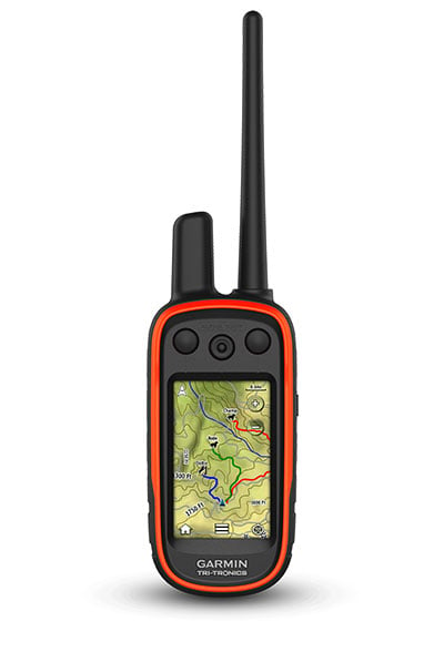
Garmin Alpha XL Dog Tracking GPS
Garmin Alpha XL Rugged Dog Tracking GPS Navigator
Track your pack from your truck. Monitor and recall your dogs in the field with the Alpha XL dog tracking GPS navigator. It shows you the way, on- or off-road, and pairs directly with your compatible dog collars via VHF radio — so you can follow up to 20 dogs from up to 4 kms away. See the location of your dogs in real time on the large 10" touchscreen display. To reach your hunting grounds, get turn-by-turn navigation for streets, unpaved roads and trails. Once in the field, off-road tools include satellite imagery, high-definition elevation maps, adventure roads and trails content, a 3-axis compass and more. Deliver training commands — from 18 levels of stim, tone and vibe — to your paired training-enabled dog collars from the touchscreen while viewing each dog’s distance traveled, average speed, barks per minute, geofencing alerts, collar battery level and other settings.
Big, Easy To Read Display
An extra-large 10" capacitive touchscreen provides a crisp high-resolution
display for easy readability while driving.
Command Central
The unit’s large touchscreen lets you deliver training commands — from 18
levels of stim, tone and vibration — to your paired collars, enabling quick
adjustments for individual dogs.
Channel View Feature
Monitor the concentration of collars in the area, and easily select less
congested channels to avoid interference.
Track Your Pack
Monitor up to 20 dogs with your compatible dog collars — from up to 4 kms
away — on the color touchscreen map display. Unit is backward compatible
with select Garmin collar devices, so you can track with existing equipment.
Hunt Metrics
See each dog’s daily hunting patterns, distance, speed and time afield, so
you can monitor performance
Satellite Imagery
Download satellite imagery to your device via Wi-Fi® technology, and see
the terrain features from above to help you navigate or find suitable habitat
for your quarry.
KEY FEATURES CONTINUED
WIRELESS CONNECTION NEW
Track and train on or off the in-vehicle dock — connecting wirelessly within 10’ for up to 2 hours.
DIRECT PAIRING NEW
Pairs directly to your compatible Garmin dog collars, so you can easily track and train straight from the Alpha XL navigator.
DOG LIST/GROUP MANAGEMENT
Store up to 250 dogs in your list, and manage active groups.
PRO VIEW COMPASS
Display shows which direction and how far away dogs are — and when a dog is “treed” or “on point.”
COLLAR MONITORING
See battery level, communication state and more for paired collars.
LOCATION AND GEOFENCING ALERTS
Know where your dogs are, and get an alert if they move outside a designated area
ALPHA® APP
Pair with the Alpha smartphone app to see and save real-time dog tracking data.
GARMIN ECOSYSTEM
Alpha XL dog tracking navigator can be integrated easily into your existing Garmin ecosystems, whether with the compatible Alpha dog collars or Alpha handhelds.
MULTI-GNSS SUPPORT
Access multiple satellite systems to track your pack in more challenging environments than GPS alone.
ABC SENSORS
Outdoor sensors include an altimeter, a barometer and a 3-axis electronic compass for rugged-terrain guidance.
MAPS FOR ON- AND OFF ROAD
Get topo and street maps of Australia and New Zealand.
TOPOACTIVE MAPS
See terrain contours, elevations, summits, parks, coastlines, rivers, lakes and more.
OUTDOOR MAPS+
Subscribe to Outdoor Maps+ to view public land information, enhanced topo maps, landowner names and more
RUGGED MOUNTING SYSTEM WITH POWERFUL VHF RADIO ANTENNA
Alpha XL features a powered magnetic VHF dock mounting system with a rugged suction cup mount and remote antenna that magnetically mounts to your vehicle, so you can track your dogs while driving with confidence.
SPECIFICATIONS FOR THE GARMIN ALPHA XL
Unit dimensions (WxHxD) 9.65" x 6.06" x 0.83" (24.5 x 15.4 x 2.1 cm)
Weight Total: 806 g (28.5 oz)
Head Unit: 554 g (19.5 oz)
Radio Mount: 252 g (9 oz)
Display type 10.1" wide view IPS, color TFT, on-lens capacitive touch panel
Display size 8.5" x 5.3" (21.6 x 13.5 cm); 10.1" (25.7 cm) diagonal
Display resolution (WxH) 1280 x 800 pixels
Battery type Rechargeable internal lithium-ion
Battery life Up to 2 hours
Internal storage 64 GB
External storage microSD card (not included)
Includes Alpha XL dog tracking GPS navigator, rugged suction cup with powered VHF mount, socket arm and 1" ball mount, 16" (40.6 cm) magnetic mount, vehicle power cable, charging/data cable, documentation

 New
New
Garmin Montana 710 Rugged GPS Touchscreen Handheld
Garmin Montana 710 Rugged GPS Touchscreen Handheld
Stay on track through all kinds of adventures.
With routable mapping for roads and trails, the Montana 710 handheld brings advanced outdoor features into a sturdy 5-inch format that’s ideal for navigation on foot, bike, kayak, ATV and more.
Rugged by Design
This durable, water-resistant handheld is tested to meet MIL-STD 810 for thermal, shock, water and vibration. It features a glove-friendly 5-inch touchscreen and is compatible with a variety of robust mounting solutions (sold separately) to best suit your activities.
Topoactive Maps
To navigate your adventures, use preloaded topographical maps. View terrain contours, elevations, coastlines, rivers, landmarks and more.
Satellite Views
Access subscription-free, high-resolution satellite imagery with direct-to-device downloads over Wi-Fi® connectivity. See photorealistic overhead views of routes and surrounding terrain, and easily create waypoints based on landmarks
Additional Maps
With 32 GB of onboard memory, you can download even more maps, such as City Navigator® maps for your drive or BlueChart® g3 charts for the water (sold separately).
Outdoor Maps+
Add a subscription to Outdoor Maps+ (sold separately), and get ongoing access to a wide variety of premium mapping content and regular updates sent right to your Garmin device via Wi-Fi technology.
Garmin Explore App
Pair with the Garmin Explore App to plan and review trip data, plus manage your waypoints, courses and activities.
More Features of Garmin Montana 710 Rugged GPS Touchscreen Handheld:
Navigation Features
- Multi-GNSS Support: Access to GPS and Galileo satellite networks enables Montana 710 to track in more challenging environments than GPS alone.
- ABC Sensors: Navigate your next trail with ABC sensors, including an altimeter for elevation data, barometer to monitor weather and 3-axis electronic compass.
- Active Weather: Access up-to-date active weather forecasts via the Garmin Connect™ app on your compatible smartphone
- Dog Tracking: For hunters and trainers, this Montana handheld syncs with your compatible Astro® or Alpha® series handhelds to help track sporting dogs in the field.
- Wikiloc Trails: This preloaded app lets you easily download hiking, cycling and other Wikiloc trails shared by outdoor enthusiasts like you. Get a free 60-day Wikiloc Premium trial to try this and other exclusive features. Learn more.
Adventure Features
- Expedition Mode: Trek far and wide off-grid. Use expedition mode, an ultralow-powered GPS reference, to keep Montana tracking for more than 2 weeks between recharges.
- Battery Options: An internal lithium-ion battery pack provides up to 24 hours of battery life in GPS mode and recharges with a standard USB-C® cable.
- Vehicle Mounts: A variety of Montana handheld-compatible mounts (sold separately) lets you adapt your navigator for use on ATVs, boats, cars, motorcycles, motorhomes or other vehicles.
Specifications for Garmin Montana 710 Rugged GPS Touchscreen Handheld:
General
- Lens Material: Chemically strengthened glass
- Dimension: 8.76 x 18.30 x 3.27 cm (3.5? x 7.2? x 1.3?)
- Weight: 410g (14.5oz) with included lithium-ion battery pack
- Water rating: IPX7
- MIL-STD-810: Yes (thermal, shock, water, vibe)
- Touchscreen
- Display Type: WVGA transflective, dual orientation
- Display Size: 6.48 x 10.80 cm (2.55?W x 4.25?H); 12.70 cm (5? diag)
- Display Resolution: 480 x 800 pixels
- Battery type: Rechargeable lithium-ion (included)
- Battery life:
- GPS Mode: up to 24 hours
- Expedition Mode: up to 440 hours
- Powered Off: up to 1 year
- Note – Battery life estimates are with full sky view and can be significantly impacted by obstructions or tree cover.
- Memory/History: 32 GB (user space varies based on included mapping)
- Interface: USB-C
Maps & Memory
- Preloaded maps: Yes (TopoActive Australia - Additional regions can be downloaded over Wi-Fi®)
- Ability to add maps
- Basemap
- Automatic routing (turn by turn routing on roads) for outdoor activities
- Map segments: 15 000
- Satellite Imagery: Yes (direct to device)
- Includes detailed hydrographic features (coastlines, lake/river shorelines, wetlands and perennial and seasonal streams)
- Includes searchable points of interests (parks, campgrounds, scenic lookouts and picnic sites)
- Displays national, state and local parks, forests, and wilderness areas
- External memory storage: Yes (32 GB max microSD™ card)
- Waypoints/favorites/locations: 10 000
- Courses: 250, 200 course points per course
- Tracks: 250
- Navigation Track Log: 20,000 points, 250 saved gpx tracks, 300 saved fit activities
- Navigation Routes: 250, 250 points per route; 50 points auto routing
- Rinex logging
Sensors
- GPS
- GLONASS
- Galileo
- Barometric altimeter
- Compass: Yes (tilt-compensated 3-axis)
- High-sensitivity receiver
- GPS compass (while moving)
Daily Smart Features
- Connect IQ™ (downloadable watch faces, data fields, widgets and apps)
- Smart notifications on handheld
- Weather forecasts
- Active Weather
- Compatible with Garmin Messenger app
- VIRB® Remote
- Pairs with Garmin Connect™ Mobile
Safety and Tracking Features
- LiveTrack
Tactical Features
- XERO™ Locations
Outdoor Recreation
- Point-to-point navigation
- TracBack®
- Area calculation
- FISH FORECAST
- Sun and moon information
- Geocaching-friendly: Yes (Geocache Live)
- Custom maps compatible: Yes (500 custom map tiles)
- Picture viewer
- LED beacon flashlight
InReach Features
- inReach remote compatible
Outdoor Applications
- Compatible with Garmin Explore™ app
- Garmin Explore website compatible
- Dog tracking: Yes (when paired to compatible dog track system)
Connections
- Connections Wireless Connectivity: Yes (Wi-Fi®, BLUETOOTH®, ANT+®)
Wi-Fi is a registered trademark of the Wi-Fi Alliance. USB-C is a registered trademark of USB Implementers Forum.
Engineering enhancements are ongoing and may not be reflected in the pictures, videos and specifications.
 New
New
Garmin Extended Battery for T 20/TT 25 Dog Tracking GPS Collars
This extended battery pack is user-replaceable and allows up to 136 hours using dynamic update rate. This Garmin Battery Pack is only for the Garmin T20 and TT25 dog devices. Includes charging clip.
Extended battery life:
- Up to 136 hours using dynamic update rate
- Up to 50 hours with 2.5 second update rate
- Up to 168 hours with 2 minute update rate
Manufacturer code: 010-13023-00

 New
New
Garmin Montana 710I Rugged GPS Touchscreen Handheld with Inreach Technology
Garmin Montana 710I Rugged GPS Touchscreen Handheld with Inreach Technology
Stay on track and in touch through all kinds of adventures.
Get advanced outdoor features — plus inReach technology for two-way messaging and interactive SOS alerts1 — in a rugged 5-inch format that’s ideal for navigation on foot, bike, kayak, ATV and more.
Global Connectivity
With an active inReach subscription, you can stay connected even when your adventures go off grid. Instead of relying on smartphone coverage, now your messages, SOS and tracking are transferred via the 100% global Iridium® satellite network
Rugged By Design
This durable, water-resistant handheld is tested to meet MIL-STD 810 for thermal, shock, water and vibration. It features a glove-friendly 5-inch touchscreen and is compatible with a variety of robust mounting solutions (sold separately) to best suit your activities.
Topoactive Maps
To navigate your adventures, use preloaded topographical maps. View terrain contours, elevations, coastlines, rivers, landmarks and more.
Satellite Views
Access subscription-free, high-resolution satellite imagery with direct-to-device downloads over Wi-Fi® connectivity. See photorealistic overhead views of routes and surrounding terrain, and easily create waypoints based on landmarks.
Outdoor Maps+
Add a subscription to Outdoor Maps+ (sold separately), and get ongoing access to a wide variety of premium mapping content and regular updates sent right to your Garmin device via Wi-Fi technology.
Garmin Explore App
Pair with the Garmin Explore App to plan and review trip data, plus manage your waypoints, courses and activities.
More Features for Garmin Montana 710I Rugged GPS Touchscreen Handheld with Inreach Technology:
Navigation Features
- Multi-GNSS Support: Access to GPS and Galileo satellite networks enables Montana 710i to track in more challenging environments than GPS alone.
- ABC Sensors: Navigate your next trail with ABC sensors, including an altimeter for elevation data, barometer to monitor weather and 3-axis electronic compass.
- City Navigator Maps: Seamlessly transition from trails to road navigation with preloaded New Zealand Navigator street mapping, which guides your drive with easy-to-follow turn-by-turn directions.
- Additional Maps: With 32 GB of onboard memory, you can download even more maps, such as BlueChart® g3 charts for the water (sold separately).
- Active Weather: Access up-to-date active weather forecasts via the Garmin Connect™ app on your compatible smartphone
- Dog Tracking: For hunters and trainers, this Montana handheld syncs with your compatible Astro® or Alpha® series handhelds to help track sporting dogs in the field.
- Wikiloc Trails: This preloaded app lets you easily download hiking, cycling and other Wikiloc trails shared by outdoor enthusiasts like you. Get a free 60-day Wikiloc Premium trial to try this and other exclusive features.
Inreach Features
- Two-Way Messaging: Exchange text messages with loved ones back home, or communicate via inReach device to inReach device in the field1.
- Interactive SOS: In case of emergency, trigger an interactive SOS message to Garmin Response?, a 24/7-staffed professional emergency response coordination centre1.
- Inreach Weather: Available inReach weather forecast service provides detailed updates directly to your Montana handheld or paired devices, so you’ll know what to expect en route1.
- Live Tracking: Using your live tracking page, followers can see your progress, ping your device to see your GPS location and exchange messages during your trip1.
Adventure Features
- Expedition Mode: Trek far and wide off-grid. Use expedition mode, an ultralow-powered GPS reference, to keep Montana tracking for more than 2 weeks between recharges.
- Battery Options: An internal lithium-ion battery pack provides up to 24 hours of battery life in GPS mode and recharges with a standard USB-C® cable.
- Vehicle Mounts: A variety of Montana handheld-compatible mounts (sold separately) lets you adapt your navigator for use on ATVs, boats, cars, motorcycles, motorhomes or other vehicles.
Specifications for Garmin Montana 710I Rugged GPS Touchscreen Handheld with Inreach Technology:
General
- Lens Material: Chemically strengthened glass
- Dimension: 9.19 x 18.30 x 3.27 cm (3.6? x 7.2? x 1.3?)
- Weight: 410g (14.5oz) with included lithium-ion battery pack
- Water Rating: IPX7
- MIL-STD-810: Yes (thermal, shock, water, vibe)
- Touchscreen
- Display Type: WVGA transflective, dual orientation
- Display Size: 6.48 x 10.80 cm (2.55?W x 4.25?H); 12.70 cm (5? diag)
- Display Resolution: 480 x 800 pixels
- Battery Type: Rechargeable lithium-ion (included)
- Battery Life:
- GPS Mode: up to 24 hours (including when a text message or location is sent every 10 minutes)
- Expedition Mode: up to 440 hours or up to 300 hours with a text message or location sent every 30 minutes
- Powered Off: up to 1 year
- Note – Battery life estimates are with full sky view and can be significantly impacted by obstructions or tree cover.
- Memory/History: 32 GB (user space varies based on included mapping)
- Interface: USB-C
Maps & Memory
- Preloaded Maps: Yes (TopoActive Australia, New Zealand & Africa; City Navigator Australia, New Zealand & Africa - Additional regions can be downloaded over Wi-Fi®)
- Ability to Add Maps:
- Basemap:
- Automatic Routing (Turn by Turn Routing on Roads) For Outdoor Activities
- Automatic Routing (Turn by Turn Routing on Roads) For Motorized Vehicles
- Map Segments: 15 000
- Satellite Imagery: Yes (Direct to Device)
- Includes detailed hydrographic features (coastlines, lake/river shorelines, wetlands and perennial and seasonal streams)
- Includes searchable points of interests (parks, campgrounds, scenic lookouts and picnic sites)
- Displays national, state and local parks, forests, and wilderness areas
- External memory storage: Yes (32 GB max microSD card)
- Waypoints/favorites/locations
- Courses: 250, 200 course points per course
- Tracks: 250
- Navigation Track Log: 20,000 points, 250 saved gpx tracks, 300 saved fit activities
- Navigation Routes: 250, 250 points per route; 50 points auto routing
- Rinex logging
Sensor
- GPS
- Galileo
- Barometric altimeter
- Compass: Yes (tilt-compensated 3-axis)
- High-sensitivity receiver
- GPS compass (while moving)
Daily Smart Features
- Connect IQ™ (downloadable watch faces, data fields, widgets and apps)
- Smart notifications on handheld
- Weather forecasts
- Active Weather
- Compatible with Garmin Messenger app
- VIRB® Remote
- Pairs with Garmin Connect™ Mobile
Outdoor Recreation
- Point-to-point navigation
- TracBack®
- Area calculation
- FISH FORECAST
- Sun and moon information
- Geocaching-friendly: Yes (Geocache Live)
- Custom maps compatible: Yes (500 custom map tiles)
- Picture viewer
- LED beacon flashlight
Inreach Features
- Interactive SOS
- inReach weather
- Send and receive text messages to SMS and email
- Send and receive text messages to other inReach device
- Send and receive group messages
- Exchange locations with other inReach device
- MapShare compatible with tracking
- Virtual keyboard for custom messaging
- Send waypoints to MapShare during trip
- Send route selection to MapShare during trip
Tactical Features
- XERO™ Locations
- Ballistics solver
Outdoor Applications
- Compatible with Garmin Explore™ app
- Garmin Explore website compatible
- Smart switching between Wi-Fi, Mobile and Satellite with Garmin Messenger app
- Dog tracking: Yes (when paired to compatible dog track system)
Safety and Tracking Features
- LiveTrack
*Active satellite subscription required. Some jurisdictions regulate or prohibit the use of satellite communication devices. It is the responsibility of the user to know and follow all applicable laws in the jurisdictions where the device is intended to be used.
Wi-Fi is a registered trademark of the Wi-Fi Alliance. USB-C is a registered trademark of USB Implementers Forum.
Engineering enhancements are ongoing and may not be reflected in the pictures, videos and specifications.

 New
Sale
New
Sale
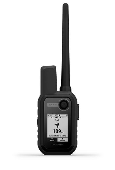
Garmin Alpha 10 GPS Handheld
The Garmin Alpha 10 is a small device with big tracking and training potential.
Key Features:
• When you’re on the move, this compact GPS device won’t weigh you down.
• Know your dog’s location, wherever the hunt takes them.
• Always on the go? Mount Alpha® 10 in your truck or anywhere else to keep it close.
• It’s up to you. Use Alpha® 10 on its own or with other dog tracking devices.
• See your dog’s location from the driver’s seat of your truck or even from your wrist.
• Stay on the hunt for longer with up to 1 week of battery life (40 hours of use).
For more flexibility on the hunt, the compact Alpha® 10 handheld can be used on its own, connected to your compatible smartphone or connected to other Garmin dog tracking devices. Map, track, sync and share from anywhere using the Garmin Explore app.
Features:
TRACK YOUR PACK. Alpha® 10 works with T5 and TT™ 15 dog devices to monitor up to 20 dogs from up to 10 kilometres with a 5-second update rate.
MULTI-GNSS SUPPORT. Access multiple global navigation satellite systems (GPS and Galileo) to track in more challenging environments than GPS alone.

HUNT-READY BATTERY LIFE. With up to a full week’s worth of battery life (40 hours of use), you’ll stay charged and ready for action, even on multiday trips.
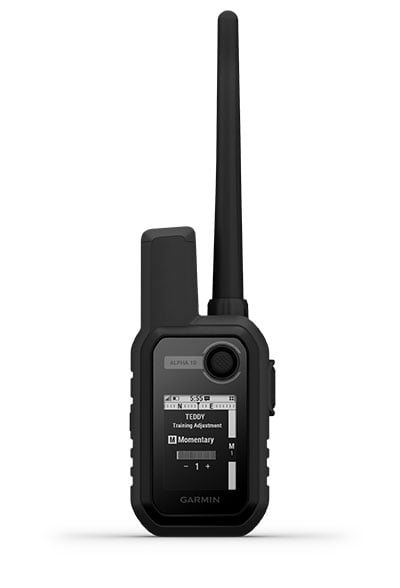
18 LEVELS OF STIMULATION. Momentary and continuous stimulation options let you customise training for each dog (when paired with select dog devices).
TONE/VIBRATION. Issue different levels of audible tone or vibration commands for quick adjustments to individual dogs (when paired with select dog devices).
GARMIN EXPLORE™ APP. Pair with the Garmin Explore app on your compatible smartphone to see real-time dog tracking information, save collections of dog tracks and replay tracks to see exactly what happened during your hunt.
FOLLOW THE ACTION. Track fellow hunters by pairing Alpha® 10 with other compatible Alpha and Astro® handheld devices.
MORE WAYS TO TRACK ON THE GO. See the pack’s location from your vehicle with the Montana, Garmin DriveTrack™ 71 sat-nav — or from your wrist with your Instinct®, tactix® or fēnix® GPS watch.
Specifications:
- PHYSICAL DIMENSIONS: 2.3 x 4.8 x 1.1″ (5.8 x 12.1 x 2.9 cm); dimensions do not include antenna
- DISPLAY SIZE: 1.8″ (45 mm) diagonal
- DISPLAY RESOLUTION: 128 x 128 pixels
- DISPLAY TYPE: Sunlight-readable, monochrome, transflective memory-in-pixel (MIP)
- WEIGHT: 5.6 oz (160 g) with standard antenna and spine mount attached
- BATTERY TYPE: Rechargeable internal lithium-ion; nonreplaceable
- BATTERY LIFE: Up to 1 week (40 hours of use)
- WATER RATING: IPX7
- HIGH-SENSITIVITY RECEIVER: Yes (GPS and Galileo)
- INTERFACE: microUSB™
- COMPASS: Yes (tilt-compensated 3-axis)
- Two-way Radio Features
- FREQUENCY BAND: MURS
- RANGE: TT 15/T 5 = 14.5 kilometres; TT 15 mini/T 5 mini = 6.5 kilometres
- COMPATIBLE WITH GARMIN EXPLORE™ APP: Yes
- GARMIN EXPLORE WEBSITE COMPATIBLE: Yes
- WIRELESS CONNECTIVITY: Yes (Bluetooth® Low Energy and ANT+®)
- ADDITIONAL: Track storage, up to 10 days
- PRODUCT NUMBER: 010-02290-53

 New
Sale
New
Sale
Garmin inReach Messenger Plus SOS Satellite Communicator | Photo & Voice Messaging
Tell them you miss them. Show them the view. Share the experience. With an active inReach subscription, the trailblazing inReach Messenger Plus SOS satellite communicator1 lets you exchange text, photo and voice messages2 when your adventure takes you beyond cellular range. Plus the durable design withstands extreme temperatures and the battery lasts for weeks.
Exchange Photos
Send a selfie or share the sunset, no mobile signal required. This requires pairing with the Garmin Messenger app on your compatible smartphone.
Exchange Voice Messages
Tell them you miss them with a 30-second voice message, no cell coverage needed. This requires pairing with the Garmin Messenger app on your compatible smartphone.
Two-Way Text Messaging
Exchange text messages with up to 1,600 characters directly on the device. Connect your compatible smartphone to the Garmin Messenger app, and exchange text messages, send emojis, or start a group chat.
Interactive SOS
Explore with peace of mind knowing you can send an interactive SOS message with your GPS coordinates to Garmin Response, a 24/7-staffed international coordination centre for help in an emergency. And, instead of relying on tower-based mobile phone coverage, your messages are sent via the 100% global iridium satellite network.
Show Them Your Route
Share your GPS location and your route anytime with live tracking. You can also embed your GPS coordinates with your text, photo or voice messages.
Garmin Explore App
Plan your trip, see your track on a map, save an activity, and view a course highlight showing how much farther to your destination when paired with the Garmin Explore app on your compatible smartphone.
More Features for Garmin inReach Messenger Plus:
- Check-In Messages: Send simple check-in messages that do not count toward your allotted text messages.
- Sync Your Contacts: Easily find your contacts with the Garmin Messenger app and your compatible smartphone.
- Seamless Connection: Use Wi-Fi® wireless technology or the cellular connection of your smartphone to send messages. Once you’re beyond mobile phone service or Wi-Fi connection, the device seamlessly switches to the satellite network.
- Group Messaging: Use your smartphone and the Garmin Messenger app to send group messages.
- Control Remotely: Send and receive text messages, or trigger an interactive SOS message remotely by using select compatible Garmin products
- On-Device Display: Use the screen to confirm that messages have been sent, send messages and read responses, even when your phone battery dies.
- GPS Accuracy: The built-in antenna automatically acquires satellites to update your latitude and longitude positions; no need to point your device directly towards the sky to find satellites.
- Send and receive 1,600 character messages
- Exchange locations with other inReach device
- MapShare compatible with tracking
- Virtual keyboard for custom messaging
- inReach remote compatible
- GPS compass (while moving)
Built for the Back Country:
- Rugged Design: Made to operate in extreme temperatures, the compact inReach® Messenger Plus is tough, durable, impact-resistant and water-rated to IPX7.
- Inreach Weather: Get weather reports. You can even request forecasts for your destinations.
- Trackback Routing: Use this feature to navigate back to where you started the same way you came.
- Safety Charging: Dead phone battery? Connect your phone to the device and use the device’s battery to charge it.
- Battery that Lasts: The internal, rechargeable lithium battery gives you up to 25 days of battery life in 10-minute tracking mode.
Specifications for Garmin inReach Messenger Plus:
- Lens Material: Chemically strengthened glass
- Dimensions: 7.8 x 6.4 x 2.3 cm ( 3.1″ x 2.5″ x 0.9″)
- Weight: 117.2 g (4.1 oz)
- Water Rating: IPX7
- Display Type: Sunlight-readable, monochrome, transflective memory-in-pixel (MIP)
- Display Size: 2.53 x 1.1 cm 2.74 cm diagonal (1″ x 0.43″, 1.08″ diagonal)
- Display Resolution: 160 x 68 pixels
- Automatic Routing (Turn by Turn Routing on Roads)
- Satellite Imagery
- Includes detailed hydrographic features (coastlines, lake/river shorelines, wetlands and perennial and seasonal streams)
- Includes searchable points of interests (parks, campgrounds, scenic lookouts and picnic sites)
- Displays national, state and local parks, forests, and wilderness areas
- Waypoints/favorites/locations
- Courses
Disclaimer: Satellite subscription required. Some jurisdictions regulate or prohibit the use of satellite communication devices. It is your responsibility to know and follow all applicable laws in the jurisdictions where the device is intended to be used.

 New
New
Garmin Alpha 300 Handheld Dog Track and Trainer
GARMIN ALPHA 300 HANDHELD DOG TRACK AND TRAINER
STRONG CONNECTION. STRONG BOND.
Sagebrush plateaus, rolling prairies, dense hardwoods, rocky ridges — no matter where you hunt, you and your dogs need reliable gear. Track and train your dogs in the field1 with the Alpha® 300 handheld, featuring a new vivid 3.5? touchscreen and user-friendly 6-button design. Track your dogs in the field1 with the Alpha® 300 handheld, featuring a new vivid 3.5? touchscreen and user-friendly 6-button design.
Key Features
- INTERACT WITH A RESPONSIVE TOUCHSCREEN AND BUTTONS
- TRACK AND TRAIN YOUR PACK IN THE FIELD
- THE USER-REPLACEABLE BATTERY LASTS UP TO 55 HOURS
- NAVIGATE WITH TOPOACTIVE MAPS AND DOWNLOADABLE SATELLITE IMAGERY
VIVID DISPLAY AND TOUCHSCREEN
See your maps and track your dogs on an even brighter 3.5? display with up to a 2.5-second update rate. Easily interact with the device on a responsive touchscreen, even with gloves on, and read the screen in a variety of light conditions.
CHANNEL VIEW
Monitor the concentration of collars in the area, and easily select less congested channels to avoid interference.
TRACK YOUR PACK
Monitor up to 20 dogs with your compatible dog collars — from up to 14.5 kilometres away — on the colour touchscreen display.
TRAIN YOUR PACK
Use dedicated buttons for fast training cues and command initiation. Select from 18 levels of momentary and continuous stimulation. Hunters can also issue different levels of audible tone or vibration commands1.
DOG METRICS
See critical hunt metrics, such as distance, speed and time afield, right on the dog info screen1.
SATELLITE IMAGERY
Download satellite imagery via Wi-Fi® technology to your device, and see the terrain features from above to help you navigate or find suitable habitat for your quarry.
Handheld Features
LONG-LASTING BATTERY
The user-replaceable battery lasts up to 55 hours.
GROUP MANAGEMENT
Save time at the start of every hunt with groups of dogs and people that match how and whom you hunt with.
MONITOR THE DOGS
See when a dog is “treed” or “on point.”
GARMIN EXPLORE™ APP
Pair with the Garmin Explore smartphone app to review the entire hunt and more.
BACKWARD COMPATIBLE
Easily pair the handheld to select T and TT™ series collars.
DOG LIST
Store up to 250 dogs, making it easy to switch active collars in the field.
NAVIGATION FEATURES
MULTI-GNSS SUPPORT
Access multiple global navigation satellite systems for better service in challenging environments.
PRO VIEW COMPASS
This simple, at-a-glance tracking shows which direction and how far away your dogs are.
TOPOACTIVE MAPS
Get detailed views of terrain contours, topographic elevations, summits, parks and more.
PREMIUM MAP FEATURES
Subscribe to Outdoor Maps+, and get public land information, enhanced topographic maps, landowner names and more.
ALTIMETER
The barometric altimeter helps you accurately monitor ascent and descent.
3-AXIS COMPASS
Navigate with the tilt-compensated 3-axis electronic compass — whether you’re moving or not.
Specifications
General
- DIMENSION 6.8 x 16.2 x 3.4 cm (2.7 x 6.4 x 1.3?) *dimensions do not include antenna
- WEIGHT 280 g (9.9 oz) with standard antenna and battery
- WATER RATING IPX7
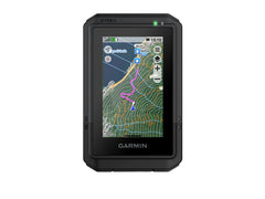
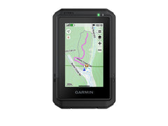
TOUCHSCREEN
- DISPLAY TYPE Transflective, colour TFT touchscreen
- DISPLAY SIZE (WxH) 4.7 cm x 7.7 cm, 3.5? diag (88.9 mm)
- DISPLAY RESOLUTION 282 x 470 pixels
- BATTERY TYPE rechargeable lithium-ion (included)
- BATTERY LIFE Up to 55 hours
- MEMORY/HISTORY 16 GB
- INTERFACE High-speed USB-C
Maps & Memory
- PRELOADED MAPS Yes (TopoActive Australia & New Zealand)
- ABILITY TO ADD MAPS Yes (see Additional)
- AUTOMATIC ROUTING (TURN BY TURN ROUTING ON ROADS) FOR OUTDOOR ACTIVITIES Yes (with optional mapping for detailed roads)
- SATELLITE IMAGERY Yes (direct to device; no annual subscription required)
- EXTERNAL MEMORY STORAGE microSD card (not included)
- WAYPOINTS/FAVORITES/LOCATIONS 10,000
- TRACKS Up to 20 assets (any combination of compatible dog devices and handhelds)
- NAVIGATION TRACK LOG 20,000 points, 250 saved spx tracks, 300 saved fit activities
- NAVIGATION ROUTES 250
- STORED CONTACTS 250 dogs
- GROUP MANAGEMENT
Sensors
- GPS
- GALILEO
- BAROMETRIC ALTIMETER
- COMPASS Yes (tilt-compensated 3-axis)
- HIGH-SENSITIVITY RECEIVER
Safety and Tracking Features
- LIVETRACK
Outdoor Recreation
- SUN AND MOON INFORMATION
- CUSTOM MAPS COMPATIBLE
Radio Features
- FREQUENCY BAND VHF
- CHANNELS 5
- RANGE 14.5 kilometres with compatible dog devices
- LOCATION REPORTING (SEND AND RECEIVE GPS POSITIONS)
- VIBRATION ALERT
- CONTACTS
Outdoor Applications
- COMPATIBLE WITH GARMIN EXPLORE™ APP
- GARMIN EXPLORE WEBSITE COMPATIBLE
- DOG TRACKING
Connections
- CONNECTIONS WIRELESS CONNECTIVITY Yes (Wi-Fi®, BLE and ANT+®)
Additional
- ADDITIONAL: Ability to add maps: yes (Outdoor Maps+)
 New
New
Garmin Pro 550 Dog Trainer System
The Garmin Pro 550 Dog Training System provides intuitive, 1-handed training for up to 3 Dogs.
• Train up to 3 dogs at a time (additional dog devices required; purchase separately)
The Garmin PRO 550 with proven Tri-Tronics® technology allows advanced training for the serious professional with easy access to 21 levels of momentary and continuous stimulation, tone as well as the ability to quickly switch between 3 dogs¹. The PRO 550 features vibration and tone settings, remotely operated beacon lights on the dog device to help locate your dog in low light, the ability to add an Upland™ Beeper (purchased separately), and a built-in BarkLimiter, activated on the dog device, to help keep the peace at home.
Features
Classic, Rugged Design: Choose from 21 levels of continuous and momentary stimulation, tone, and vibration for up to 3 dogs at a time.
The Garmin PRO 550 uses the tried and true tube-shaped design that trainers have come to love, but is easy to operate (and master) 1-handed so you can keep your eyes on your dog at all times, even while switching between stimulation levels and dogs. The stimulation level/vibrate selection dial is at the top of the transmitter, allowing intuitive operation. Tone, beacon lights and beeper are controlled using the switch, and buttons on the face of the handheld unit. And the control buttons comfortably line up in the hand for fingertip control. A 2 ½-inch fixed transmitter antenna eliminates the threat of a lost or broken antenna while delivering up to 1 mile range.
Train with Stimulation and Tone: Choose from 21 levels of continuous and momentary stimulation, tone, and vibration for up to 3 dogs at a time (additional dog devices required; purchase separately). You can also remotely operate the LED beacon lights, built-in to the dog device, and an accessory beeper (purchase separately) to help locate your dog in low light conditions.
Built-in BarkLimiter: PRO 550 features a built-in BarkLimiter, activated by the dog device. BarkLimiter features Autorise technology, which automatically adjusts correction to the optimum level needed to stop unwanted barking.
Tough, Water-resistant, Long-lasting: Both the transmitter and the dog device collar are designed to withstand all the blows, bumps and sloppy conditions of training and hunting. The dog device comes with 2 sizes of removable, stainless, insulated contact points for reliable performance in wet conditions and extended comfort for the dog. The dog device is water-rated to 1 ATM (10 meters). The PRO 550 transmitter itself is water-rated to IPX7. The transmitter and dog device both feature a long-lasting, rechargeable, lithium-ion battery. A battery life indicator on the transmitter and dog device lets you know when to recharge the system.
Collar Pairing: The color-coded dog selection switch on the PRO 550 handheld allows you to determine which dog is receiving correction. Pairing the dogs’ collar color to the color of the selection switch helps you keep track of which dog is receiving stimulation or tone. Additional 3/4 inch polyurethane-coated accessory collars are sold separately.
Specifications
Handheld Physical & Performance:
• Unit dimensions (W x H x D): 1.8" x 8.2" x 2.1" (4.5 x 20.8 x 5.4 cm)
• Weight: 7.8 oz (221 g)
• Range: 1 miles
• Multi-dog compatibility: 3
• Autorise bark correction mode: yes
• Battery: rechargeable lithium-ion (included)
• Battery life: 24 hours
• Water rating: IPX7
• Floats: yes
Handheld Features:
• Correction levels: 21
• Momentary/continuous correction: Both (low, medium and high)
• Vibration correction: yes
• Tone correction: yes (dedicated button)
• Accessory unit activation: yes
Dog Device:
• Unit dimensions, WxHxD: 3.1" x 1.7" x 1.7" (7.8 x 4.4 x 4.4 cm)
• Weight: 3.5 oz (98 g)
• Battery: rechargeable lithium-ion (included)
• Battery life: up to 40 hours
• Water rating: 1 ATM
• Floats: no
• Collar compatibility: 0.75" (1.9 cm)
Dog Device Features:
• Beacon lights: yes
• Vibration: yes
• Accessory unit activation: yes
• BarkLimiter™ mode: yes
• Tone: yes
• PRO 550 handheld
 New
Sale
New
Sale
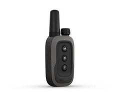
Garmin Delta SE Dog Trainer Bundle
SO SIMPLE, YOU COULD SAY WE WROTE THE BOOK
No more complex training. With the Delta SE handheld and dog collar, you and your canine companion have everything you need to sit, stay and play — the easy way.
Features:
- Train simply with the small, ergonomic 3-button handheld.
- Enjoy three ways to train, including stimulation, tone and vibration.
- A slide switch makes training up to two dogs1 easier than ever.
- Stay connected with your dog at up to a half-mile range.
- Tactile dial helps you and your dog stay focused while training.
SIMPLE AND EFFECTIVE
With its small, ergonomic design, dog training fits in the palm of your hand.
THREE WAYS TO TRAIN
Train your way, and choose between tone, vibration and 10 levels of momentary and continuous stimulation.
REMAIN FOCUSED
The tactile dial allows you to focus on your dog while training, so you never have to take your eyes off what matters.
TRAIN YOUR PACK
Get the two-in-one experience, and train up to two dogs1 with the easy-to-use slide switch.
CHANGEABLE AND REPLACEABLE CONTACT POINTS
Based on the length and thickness of your dog’s coat, choose between two contact points — long and short — and get more consistent contact during training.
TOUGH AND WATER-RESISTANT
Whether training for the house or the hunt, this rugged, water-resistant (IPX7) handheld is built to last.
In the Box:
- Bundle (Handheld and Dog Collar)
- Delta® SE handheld
- Delta® SE dog collar
- Black 1.9 cm collar strap
- Charging clip (for dog collar)
- USB-C cable
- Short and long contact points with wrench
- Lanyard
- Documentation
Specifications:
- DIMENSION Handheld: 2.1 x 4.9 x 1.1″ Dog device: 2.3 x 1.4 x 1.4″
- WEIGHT Handheld: 86 g Dog device: 71 g
- WATERPROOF: IPX7
- BATTERY TYPE: Rechargeable internal lithium-ion; nonreplaceable (both handheld and dog device)
- BATTERY LIFE: Handheld: 70+ hours Dog device: 60 hours
- INTERFACE: USB-C
- FREQUENCY BAND: 27MHz (HF)
- RANGE: 800 metres

 New
New
Garmin Montana 700 Rugged GPS Touchscreen Navigator
Explore your world with navigation you trust. With routable mapping for roads and trails, the Montana 700 handheld brings advanced outdoor features into a sturdy 5” format that’s ideal for navigation on foot, bike, kayak, ATV and more.
Expect big things. The Montana 700 features a large touchscreen puts them all at your fingertips, and routable TopoActive Australia and New Zealand maps. Now you’re free to take it off-road or on.
Meets MIL-STD 810 for thermal, shock, water and vibration, and now you can power your adventures with 18+ hours of lithium-ion battery life in GPS mode.
Get the clear perspective of BirdsEye Satellite Imagery right to your device, and go far with no fear. ABC sensors and multiple GNSS networks have your back.
• Rugged by design: This durable, water-resistant handheld is tested to U.S. military standards and features a glove-friendly 5” touchscreen that’s 50% larger than previous Montana models
Specifications:
• PHYSICAL DIMENSIONS: 8.76 x 18.30 x 3.27 cm
• DISPLAY SIZE: 6.48 x 10.80 cm; 5" diag (12.70 cm)
• DISPLAY RESOLUTION: 480 x 800 pixels
• WEIGHT: 397 g with included lithium-ion battery pack
• BATTERY TYPE: rechargeable lithium-ion (included) or 3 AA batteries (not included); lithium recommended
• BATTERY LIFE: GPS Mode: up to 18 hours; Expedition Mode: up to 330 hours
• WATER RATING: IPX7
• HIGH-SENSITIVITY RECEIVER: Yes
• INTERFACE: High speed micro USB and NMEA 0183 compatible
• MEMORY/HISTORY: 16 GB (user space varies based on included mapping)
• ABILITY TO ADD MAPS: Yes
• BASEMAP: Yes
• AUTOMATIC ROUTING (TURN BY TURN ROUTING ON ROADS): Yes (with optional mapping for detailed roads)
• MAP SEGMENTS: 15000
• INCLUDES DETAILED HYDROGRAPHIC FEATURES (COASTLINES, LAKE/RIVER SHORELINES, WETLANDS AND PERENNIAL AND SEASONAL STREAMS): Yes
• INCLUDES SEARCHABLE POINTS OF INTERESTS (PARKS, CAMPGROUNDS, SCENIC LOOKOUTS AND PICNIC SITES): Yes
• DISPLAYS NATIONAL, STATE AND LOCAL PARKS, FORESTS, AND WILDERNESS AREAS: Yes
• EXTERNAL MEMORY STORAGE: Yes (32 GB max microSD™ card)
• WAYPOINTS/FAVORITES/LOCATIONS: 10000
• TRACKS: 250
• TRACK LOG: 20000 points, 250 saved gpx tracks, 300 saved fit activities
• ROUTES: 250, 250 points per route; 50 points auto routing
• RINEX LOGGING: Yes
• GPS: Yes
• GLONASS: Yes
• GALILEO: Yes
• BAROMETRIC ALTIMETER: Yes
• COMPASS: Yes (tilt-compensated 3-axis)
• GPS COMPASS (WHILE MOVING): Yes
• CONNECT IQ™ (DOWNLOADABLE WATCH FACES, DATA FIELDS, WIDGETS AND APPS): Yes
• SMART NOTIFICATIONS ON HANDHELD: Yes
• VIRB® REMOTE: Yes
• PAIRS WITH GARMIN CONNECT™ MOBILE: Yes
• ACTIVE WEATHER: Yes
• LIVETRACK: Yes
• POINT-TO-POINT NAVIGATION: Yes
• COMPATIBLE WITH BASECAMP™: Yes
• AREA CALCULATION: Yes
• HUNT/FISH CALENDAR: Yes
• SUN AND MOON INFORMATION: Yes
• XERO™ LOCATIONS: Yes
• GEOCACHING-FRIENDLY: yes (Geocache Live)
• CUSTOM MAPS COMPATIBLE: yes (500 custom map tiles)
• INREACH REMOTE WIDGET: Yes
• LED BEACON FLASHLIGHT: Yes
• INREACH REMOTE COMPATIBLE: Yes
• COMPATIBLE WITH GARMIN EXPLORE™ APP: Yes
• GARMIN EXPLORE WEBSITE COMPATIBLE: Yes
• DOG TRACKING: Yes (when paired to compatible dog track system)
• WIRELESS CONNECTIVITY: Yes (Wi-Fi®, Bluetooth®, ANT+®)
- 1
- 2